Canterbury trail notes
Sections
Intro
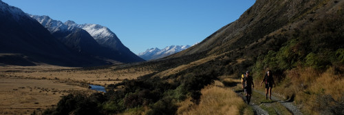
Te Araroa section: This tramp follows a historic crossing of the Southern Alps at Harper Pass (962m). Māori used the route to access pounamu (greenstone) on the West Coast, and European settlers used it for access and supply purposes during the gold rush of the 1860s. Harper Pass is named after Leonard Harper, who, at 20 years of age, became the first European to cross the pass and reach the West Coast in 1857.
Description
The old Māori and settler route of the 19th century fell into disuse from 1867 following the development of an alternative route through Arthur’s Pass, which provided more direct access to the Coast.
In the 1930s, the track was reopened and four substantial huts were constructed by the Physical Welfare Division of the Department of Internal Affairs in an attempt to recreate the Milford Track’s model for tourism success. While the Harper Pass Track has never reached the Milford Track’s status, it still affords a quality tramping experience of relative ease.
Things to keep in mind
- On the West Coast side of Harper Pass, the route requires numerous crossings of the Taramakau and Otehake Rivers. Trampers with river-crossing skills and experience will find these rivers passable in normal to low flows but impassable when river levels are high. Extra food should be carried to enable trampers to backtrack or to wait until river levels subside.
- In a number of areas, this route requires a lot of self-navigation as it is not fully marked. Generally, this is straightforward though you’ll want to be carrying GPS, maps and a compass to assist you.
- The traditional Harper Pass Track starts at Windy Point and ends at Aitkens.
St James Car Park (Boyle Village) to Hope-Kiwi Lodge - 26.5km / 8 hours
Follow the Tūi Track sign and markers to the highway and then on the landward side of the fence on the left to a driveway leading to the old Boyle Base Hut. Cross the road here and follow the markers down to a terrace and then along to the Boyle River.
If safe to cross, ford the Boyle River where markers indicate and continue down the true right bank on river flats to the confluence with the Doubtful River.
If the river can not be crossed safely, back-track and continue down on the road shoulder for about 2 hours to the signpost marking the entrance road to the Lake Sumner Forest Park at Windy Point. You will pass the Engineers Camp along the way. There is a car park and shelter at Windy Point, a short distance down the entrance road. This marks the alternative and traditional starting point to the Harper Pass Track.
After fording the Doubtful River where marked, the track continues down the true right of the Boyle River and joins a farm track that leads onwards to a deer fence. Follow this fence until markers show the track heading uphill through mānuka and beech forest towards the main Hope Valley track. Te Araroa joins the Harper Pass Track proper here. Turn right, and the track climbs through mānuka scrub and farmland to the beech forest’s edge. Once inside the forest, the track sidles above the Hope River to Hope Shelter, and a basic hut (6 bunks) can be found, which is old but still in reasonable condition. There is no water supply at the hut itself, so a walk down to the river could be required.
DOC estimate 4 hours from Windy Point to Hope Halfway Hut (Hope Shelter) (8 km)
Beyond Hope Shelter, the track continues through the forest and then breaks out across grassy flats. The track then crosses the Hope River on a swingbridge. Across the bridge, there is a junction with the track to St Jacob’s Hut. From here, Te Araroa heads south on the track to Hope-Kiwi Lodge, situated in a large clearing near the forest edge.
DOC estimate 3 hours from Hope Halfway Hut to Hope Kiwi Lodge (7 km)
Hope-Kiwi Lodge to Hurunui Hut — 19km / 6 hours
Below Hope-Kiwi Lodge the track crosses open cattle flats and then climbs through the bush towards Kiwi Saddle (677m). A lookout nearby affords good views of Lake Sumner. Beyond the saddle, the track descends towards the lakeshore and to a swingbridge over Three Mile Stream. Cross the bridge, continue to the lake head and beyond up the Hurunui River’s true left side. Keep to the marked track until it deviates across the valley to another swingbridge, this time over the Hurunui River. Once on the other side of the river, the track climbs and sidles for about 30 minutes to Hurunui Hut, a modern hut with sleeping platforms and elevated views over the valley below.
After crossing the Hurunui swingbridge southbound, dismount on the left side. There is a short steep climb to reach the path, which then sidles to the right above the bridge anchors. It may seem logical to turn right immediately at the end of the bridge, but this leads to a dead-end and forces a rough scramble up to rejoin the track.
Hurunui Hut to Hurunui No.3 Hut - 10km / 4-5 hours
The track descends from the hut through the mānuka forest to the open flats of the valley floor. About 2-thirds of the way, a sign indicates access to a hot pool (look for the steam rising from the stream just before that). Another sign at the pool warns; “Amoebic meningitis is fatal and caused by water entering nasal passages. Do not immerse head”. As long as you ensure your head stays above the water, feel free to swim in the pool, as it is a Te Araroa highlight.
The sign indicating the hot spring may not be visible. Southbound walkers will encounter a small warm-water stream running down a rough rock face. The trail climbs the bank another 20 m past the warm steam, and the pool is accessed via a short side trail that may be marked with a small rock cairn.
Beyond the hot spring, the track continues through flats and forest on the Hurunui’s true right all the way to Hurunui No.3 Hut. While one of the original 4 huts on the route, the No.3 Hut remains a comfortable (16 bunk) hut. It has an unusual-looking DOC research building nearby.
Hurunui No.3 Hut to Locke Stream Hut — 15km / 7 hours
Soon after leaving the No. 3 Hut, the track crosses Cameron Stream. An emergency 3-wire bridge can be used here to avoid getting wet feet. Continue across the flat towards Cameron Hut (4 bunks). This hut offers basic emergency accommodation for anyone in need. There is a fireplace, and the bunks were rebuilt in early 2021. As of February 2021, only two of the four bunks are usable
Beyond Cameron Flat the track leaves cattle country and ascends towards Harper Pass Bivvy, a cramped 2 bunk box with one tiny window and a helpful sign on the door that reads ‘fire exit’.
From the bivvy, the track crosses the Hurunui headwaters and climbs more steeply for 30 minutes to Harpers Pass. Kiwi are present in the area in reasonable numbers and can be heard at night. Watch out for their 3-pronged footprints as they are sometimes visible where the ground is soft.
On the West Coast side of the Pass, the track drops steeply and crosses the Upper Taramakau River to the true right side. It continues down to a swingbridge, which takes trampers to the true left side. From here, it is about 1.5 hours downstream to Locke Stream Hut.
Locke Stream Hut is another Physical Welfare Division classic. It was built in 1940 with hand-hewn timber by 65-year-old packman, Sam Burrows. The hut was restored in 1993 through a bequest from Tom Beeston’s estate.
Locke Stream Hut to Morrison footbridge via Aitkens — 23km / 6-8 hours
Beyond the hut, travel is down the Taramakau River through bush and open river terraces — though some pieces of track are affected by river damage. Travel is often in the riverbed and can require numerous river crossings that become impassable after heavy rain.
Kiwi Hut (6 bunks) is located approximately halfway down the Taramakau (8km/3.5hr from Locke Stream Hut) and a 15-minute walk from the Kiwi Hut junction.
Cross the Taramakau (to the true left) approximately 1km after the Kiwi Hut junction and then cross the Otehake River to continue on the true left of the Taramakau. When the rivers are running high, the Otehake may be the more dangerous of the two as it has a larger catchment. If the Taramakau River looks doubtful, it may be wiser to return to Kiwi Hut and wait for the rivers to drop.
Previous advice to walk down the true right of the Taramakua from Kiwi Hut to cross just past Pfeifer Creek, following a 4WD route, has had to be changed as the river now cuts close to the right bank opposite the Otehake confluence, causing walkers to venture onto private property and pass private huts. Landowners have required DOC to modify the route
The previous instructions are retained here in the hope that the right bank route can be restored in future. It previously offered a safer alternative when the river levels were high
For southbound, do not cross the Taramakau River at km 2166. Flood debris on the south (true left) bank below the Otehake River confluence makes the trail impassable. Continue on the true right for 4.5 km, utilising the 4WD track where visible, to cross the Taramakua River after (west of) Pfeifer Creek
[For northbound, cross to Taramakau River north (true right) bank at km 2171.5 where the 4WD turns into the river bed, shortly before Pfeifer Creek. Flood debris on the south bank makes the trail impassible between the Pfeifer Creek and the Otehake River confluence. Cross where the 4WD track crosses and follow the 4WD track, where visible, along the north bank river bed for 4.5 km to pick up the trail markings again. ]
Southbound continued. The route is then mainly on the true left all the way down to the sign-posted turn-off onto the Flood Track to the Morrison Footbridge - though due to river movement at times, travel may be through the riverbed and require crossings.
Trampers wishing to exit to the Aitkens carpark on SH73 should continue down the Taramakau and then carefully ford the Otirā River at the marked point, aiming approximately towards the radio aerials on the far bank. Choose the crossing point with care, as the river may form deep pools.
Meanwhile, Te Araroa continues left on the Flood Track for 2hr and joins with the Mingha-Deception Track at the Morrison Footbridge. The Flood Track is poorly formed, through the bush and involves a series of sharp climbs and descents along a steep face above the Otirā River - when the Otirā River is low, walkers may prefer to walk along the riverbed, though carefully judge the water level before attempting this. The flood track was clear of obstacles in January 2021 but remains a difficult route, best avoided if the river is low enough for safe travel along the river bed. Cross the footbridge to access SH73. There is a carpark across the road.
From Aitkens, turn left for 22km to Arthur’s Pass, a small alpine village, or turn right for 73km to Greymouth on the West Coast.
Mingha — Deception Track
This route forms the mountain run component of the celebrated Coast-to-Coast race. Top athletes complete it in around 3 hours. On the Deception side, the track is rough and not regularly marked. However, in good conditions, it is a reasonable route which most trampers take 2 days to complete. The route involves many river crossings, so is vulnerable to bad weather. Do not attempt it in heavy rain or when heavy rain is forecast. Come prepared to wait out flood conditions. The area is home to rare and protected blue duck/whio. DOC asks for sightings to be reported to staff at the Visitor Centre in Arthur’s Pass.
SH73 – Goat Pass Hut — 14.5km / 8-9 hours
Coming from SH73, cross the Otira River on the Morrison footbridge and follow the Deception River up the true right side across river flats. Cross to the true left and follow rock cairns through the lower gorge, re-crossing the river where necessary. Continue up to Good Luck Creek. Upper Deception Hut, which is easy to miss, is located a short distance beyond, on the true right side.
Beyond the hut, trampers can pick their way upwards, mostly in the riverbed though there are some small tracked portions under bush cover. There is a final steep climb over rough terrain to get up to the Goat Pass Hut (20 bunks), located a short distance below the pass itself. This hut has a radio link to DOC’s visitor’s centre at Arthur’s Pass, which trampers can use to obtain weather forecasts and other information.
Goat Pass Hut to SH73 Bealey River — 9.5km / 5 hours
From the hut, the track improves significantly but still has many river crossings. The track crosses Goat Pass on boardwalk sections and then descends towards the bush line into the Mingha Valley. The track departs the river course towards Dudley’s Knob to avoid a difficult gorge and continues down to the Lower Mingha flats. Look for a safe crossing of the Bealey River near its confluence with the Mingha River and continue down towards Greyney (this is only a day shelter — no camping) on SH73. The track line rises to the road along the way. The closest alternatives are Klondyke Corner on the banks of the Waimakariri and Avalanche Creek in Arthur’s Pass village, both $8/person/night.
Conditions
Experience: Suitable for well-equipped people with previous backcountry tramping and river-crossing experience.
Best season: Summer, autumn and winter
Required maps:
- NZTopo50 Moana BU20
- Haupiri BU21
- Lake Sumner BU22
- Boyle BU23
Hazards: Flooded rivers, steep drop-offs
Safety: This route guide must be read in conjunction with Tramping in Arthur's Pass National Park (PDF, 762K) (opens in new window), and New Zealand's Outdoor Safety Code (external site).
Before setting out, check the latest track conditions and avalanche advisory with the
Before you go, tell someone your plans and leave a date to raise the alarm if you haven't returned. To do this, use the New Zealand Outdoors Intentions process (external site) on the AdventureSmart website. It is endorsed by New Zealand's search and rescue agencies and provides three simple options to tell someone you trust the details about your trip.
Arthur's Pass (Carroll Hut) weather - NIWA
Arthur's Pass (Carrington Hut) weather - NIWA
Arthur's Pass (Avalanche Peak) weather - NIWA
Arthur's Pass (Visitor Centre) weather - NIWA
Transport
Getting there/away - To Christchurch and Greymouth
- East West Coaches - E: book@eastwestcoaches.co.nz - P: 027 201 8825
Greymouth
- Atomic Shuttles - P: 03 349 0697
- East West Coaches - E: book@eastwestcoaches.co.nz - P: 027 201 8825
Accomodation
En route
- Hope Kiwi Lodge - 20 bunks
- Hurunui Hut - 15 bunks - a modern hut with sleeping platforms and elevated views over the valley below
- Hurunui No. 3 Hut - 16 bunks - While one of the original 4 huts on the route, the No. 3 Hut remains a comfortable 16 bunk hut.
- Locke Stream Hut - 18 bunks
- Kiwi Hut - 6 bunks
- DOC's Goat Pass Hut - 20 bunks - This hut has a radio link to DOC’s Visitor’s Centre at Arthur’s Pass, which trampers can use to obtain weather forecasts and other information
Arthur's Pass
- Mountain House Arthur's Pass - 84 West Coast Road, Arthur's Pass Village, Canterbury 7875, P: 03 318 9258 E:mountainhouseap@gmail.com Now stocking Backcountry Cuisine meals. Bounce boxes accepted $10.
- Arthurs Pass Motel and Lodge - 03 318 9099
- Arthurs Pass Alpine Motel - Main Rd (SH 73), Arthurs Pass Village, W Coast Rd, Arthur's Pass - P: 0800 900 401 or 03 318 9233
- Nigel Marx's Arthur's Pass hut -see Food and supply section below
- YMCA Arthur's Pass Outdoor Education Centre - Dorm rooms and private rooms available (Oct - Feb) 83 West Coast Road, Arthur's Pass village P: 03 318 9249 E: apoec@ymcachch.org.nz
- The Sanctuary has closed.
Bill has retired due to old age and has closed The Sanctuary.
Bounce boxes held or already in transit can still be collected as expected.
Text 0274 662 755 on arrival.
No more boxes please.
The community of Te Araroa walkers will always be remembered. Thank you all.
Enjoy your adventure.
Bill Trolove
The Sanctuary
Greymouth
- YHA Greymouth Kāinga-Rā Backpackers - 15 Alexander St, Greymouth - P: 03 768 4951
- Global Village Travellers Lodge BBH - 42-54 Cowper St, Greymouth - P: 03 768 7272
Many other accommodation options are available in Greymouth.
Food and Supply
Resupply + Bounce Box
- Arthurs Pass Alpine Store and Tearooms - P: 03 318 9235 - fuel also available
- Mountain House Arthur's Pass - 84 West Coast Road, Arthur's Pass Village, Canterbury 7875, P: 03 318 9258 E:mountainhouseap@gmail.com. Bounce boxes accepted $10.
- The Bealey Hotel will receive Food Packages $10 per box if you are staying there, otherwise $15. Send to The Bealey Hotel PO Box 51058, Arthurs Pass 7654. Please include your name and Estimated Arrival Date 12858 West Coast Road. For Box collection, Check the Bealey Website www.thebealeyhotel.com for up to date details on open hours and accommodation availability, or email them at stay@thebealeyhotel.com to arrange a day and time to collect boxes.
- Update 25 January 2024. The Bealey Hotel is no longer accepting bounce boxes - boxes already accepted are safe and will be available for collection, but no more please
- Nigel Marx accepts bounce boxes for Arthur's Pass. He can store boxes as long as they are sent to his home address in Christchurch time to be taken up to Arthur's Pass before you arrive. He's usually up there 2-3 times a month over the summer so the box needs to arrive at his home at least 2-3 weeks before you expect to be at the Pass. Secure storage with all-hours access. Access is by calling him for directions to find the hut and the keys. There is sometimes a modest self-contained hut available for TA walkers, koha accepted. It can sleep four at a pinch, but comfortable for two. He can also store long term luggage at his business lock-up in Christchurch. Nigel Marx, nigelmarx@yahoo.co.nz +64 27 537 4686
- Update 22 January 2024. Nigel Marx is temporarily unable to accept any more bounce boxes - there's not enough room
- The Sanctuary has closed.
Bill has retired due to old age and has closed The Sanctuary.
Bounce boxes held or already in transit can still be collected as expected.
Text 0274 662 755 on arrival.
No more boxes please.
The community of Te Araroa walkers will always be remembered. Thank you all.
Enjoy your adventure.
Bill Trolove
The Sanctuary
Greymouth
- New World Supermarket - 128 High St - P: 03 768 4441
- Countdown Supermarket - 174 Māwhera Quay - P: 03 769 9210
Intro
Te Araroa section: One of the highlights of this section of Te Araroa is passing the alpine Lake Coleridge (Whakamatau) situated in a glacier-formed valley. When you reach the Rakaia River, you’ll see one of the largest braided rivers in New Zealand.
Description
Klondyke Track - 9km / 2-3hr
The Klondyke Track is a Te Araroa-specific link. It reduces the road connection between the Deception-Mingha and Harper River Tracks.
The track starts at the Mingha and Bealey River junction. It heads south on the flood control bank, initially following orange marker poles (these turn off to the Greyney Shelter carpark that is no longer a campsite, despite the old label on maps). Continue following the flood control bank, and carefully cross the railway line into the gravel quarry; a poled and marked route starts at the Bealey River / Greyney’s Creek junction following a terrace beside the river towards the Klondyke Corner Campsite, this is also a predator control line (yellow markers). At Klondyke there is a basic campsite with a pavilion, carpark and toilets.
The track beyond Klondyke Corner remains on the true right bank of the Bealey River. There are occasional marker poles which lead to the Waimakariri River confluence. Cross the river as water levels allow and climb up to SH73 before the Bealey Spur settlement. If the Waimakariri is up, trampers are able to cross on the road bridge, about 1km to the west.
The Bealey Hotel, which is 12km east of Arthur’s Pass and 150km west of Christchurch, is a good point where trampers can organize transport, with most operators passing on their way to Arthur’s Pass or Christchurch.
From Bealey Spur, continue east on SH73 and follow the road’s shoulder to Cora Lynn Rd. Turn right here and walk past the Arthur’s Pass Wilderness Lodge and through the gate marked ‘Cass-Lagoon Track’. The track ends at the car park a short distance further along. Bealey Hut (6-bunks) is a five-minute walk beyond the car park, up the track and on the right-hand side.
Harper River Track
The initial section to Hamilton Hut is on DOC’s Cass Saddle–Lagoon Saddle Track and through Craigieburn Forest Park. The final portion of the track is adjacent to Glenthorne Station and finishes at Harper Rd. Here trampers are able to walk a route based on an unformed legal road, which runs along the Harper River fringe.
Cora Lynn Carpark to Hamilton Hut - 15.5km / 7-8 hours
The track climbs a short distance from the carpark to Bealey Hut, a basic 6 bunk hut off on a short side trail to the right. Beyond the hut, the track continues to climb through beech and exotic forest. It then traverses the broad north face of Mt Bruce, initially through the forest but then through open tussock country. This is up towards Lagoon Saddle.
From the Saddle, follow board-walked sections down to the bushline. Lagoon Saddle A-Frame Shelter (2 people) is a short distance lower down. The track then descends to the Harper River. The next section down to West Harper Hut has numerous river crossings, but these are straightforward in normal conditions.
West Harper Hut, with its dirt floor and canvas bunks, provides historical interest and welcome shelter in poor weather. Beyond the hut, the route is an all-weather one. The Harper River is crossed on a swing bridge. There is also a swingbridge across Hamilton Creek near Hamilton Hut.
Hamilton Hut to Harper Rd - 18km / 5-6 hours
Return to the sign at the true left side of Hamilton Creek. From here Te Araroa heads down to the Harper River confluence, beyond which the track follows the Harper River downstream. For much of the way, an old 4WD track can be used but this leads to numerous river crossings.
If the river is high, it is possible to remain on the true left all the way down to the Pinnacles without too much additional effort or time, except for a spot where a ravine has formed. This means a river crossing cannot be avoided. The river can pool adjacent to this point, so if the water is high, waiting it out or retreating to Hamilton Hut could be the wisest course of action.
The track remains within Craigieburn Forest Park until about a 1/3 of the way down to the Pinnacles. It then enters Glenthorne Station (we ask that respect is given when on this station and please stick to the route — no shortcuts. If you do, you will be charged with trespassing by the landowners) on a route based on an unformed legal road. This is along the fringe of the Harper River on the true left side. The Pinnacles become visible lower down across the river on the true right side.
Below the Pinnacles, the track continues down the Harper River, which trampers need to ford to make further progress. The best place to do this is above the Avoca River confluence. The Avoca, in turn, is crossed separately. Continue down the farm track to Harper Road and cross Harper River on the road bridge.
Harper Road reaches a junction near Harper Village where the Harper River Track ends. If you need somewhere to stay, then there is a free overnight campsite on Trustpower-owned land about 300m distant. This is down the road marked with the “2km to Lake Coleridge” sign. The campsite is signposted on the left-hand side of this road. Water is available from a tap in the campsite, and there is a modern long-drop toilet. A shelter built by Te Araroa benefactor Stephen Yeats in 2022 provides a welcome refuge from rain, wind or sun on the otherwise unprotected site.
For One (previously Vodafone) subscribers only, cellphone connection is possible at the end of the Harper River Track but not at the Harper Campsite, also referred to as the Trustpower Campsite. Cell signal starts where the trail leaves the floodbanks and crosses a wooden fence (SOBO), and continues past the Trustpower work site as far as the plywood signboard. For NOBO, you will pass through the tiny Harper Village to a T intersection. The campsite is to the left, cell signal and Te Araroa northbound is to the right
- Note - it is 48km from Hamilton Hut to Lake Coleridge - only the fastest walkers should attempt to do this in a day. There are NO places to camp between Harper Village and Lake Coleridge, so the recommended approach is to camp at the Harper Village campsite and then go from there to Lake Coleridge in a day — plan to reach Lake Coleridge before 5pm to maximise your chances of hitching a lift out to Rākaia Gorge/Methven. There is now excellent camping or dormitory accommodation on Te Araroa at km 2275.4, just before Lake Coleridge Village. Details below. Otherwise you’ll need to walk to Lake Coleridge Village and hitch out that day, or pick up a hitch along Harper Road if you don’t plan to use the local accommodation.
From Harper Village, travel 24km along Harper Road past Lake Selfe, and Lake Evelyn and over the Ryton River Road Bridge to the Homestead Road junction.
- Note: Take extreme care, this road has a 100km/h speed limit, and drivers are often not expecting walkers. Wear hi-viz clothing/pack cover, and do not use headphones. Stick to the extreme edge of the road. A person who drives this road daily and often picks up walkers has asked specifically for Te Araroa hikers to be reminded that it is safer for hikers in pairs or groups to all move to the same side of the road when a vehicle approaches. If you occupy both shoulders, he has to choose which one to avoid.
Turn right here, and Te Araroa's next section, the Lake Hill Track, starts at the stile about 900m down on the right-hand side of the road.
Lake Hill Track - 3.5km / 1¼ hours
The Lake Hill Track provides access to a section of the Lake Coleridge foreshore and joins Homestead Road with Coleridge Intake Road. In the process, it follows a narrow strip of public land which adjoins the private property.
- Note: Walkers are asked to keep strictly to the marked route and to respect the property rights of the adjoining landowners. This includes giving way to stock and farm operations and adhering to the ’no dogs, camping or fires’ conditions of access.
The track starts on Homestead Road at a stile, which is 900m from the junction with Harper and Lyndon Roads. Travel is in the direction of Lake Coleridge and is initially easy and through farmland where stock are likely to be grazing.
After about 700m, the marked route passes through a tussock section as it crosses a wetland fringe. Conditions may be damp underfoot here.
Beyond the wetland, the route joins the edge of a farm track and then veers to the left on a foot track as it approaches the lakeshore. There is a short climb and descent to avoid a bluff, and then about half a kilometre of level lakeside walking before the foot track crosses another farm track.
From the far side of the farm track, the marked route ascends away from the lake. After a short climb, the gradient eases, and the track continues to follow poles towards Coleridge-Intake Road. On its way to the road, the track joins and then departs from a farm track. Trampers need to be vigilant in following the markers to ensure they stay on the legal route.
The track ends on Coleridge-Intake Road at the stile next to the farm gate. This is about 1.3km below the intersection with Algidus Road.
Walk south up Coleridge Intake Road (away from the lake) from the Lake Hill Track trailhead towards the Algidus Road intersection. Continue through the intersection on Coleridge Intake Road. Beyond the cattle stop, the road and surrounding land are owned by Trust Power. Coleridge Intake Road enters a pine forest and veers to the right.
The track leaves Coleridge Intake Road on the right as the road makes a hairpin turn to the left. Look out for markers here and a track that has been cut through the broom. This formed track quickly opens up and, for a few metres, follows the pipes down towards the power station before turning left to enter a pine forest.
Lower down the track leaves the forest, turns right, and descends directly through open country. It enters the Arboretum at a gate on the left and follows a well-formed path passing a number of signposted specimen trees along the way. The track end is through the memorial gate marking the exit from the Arboretum to Hummocks Road.
The Arboretum comprises a site of approximately 2 hectares and was established in 1933 by Harry Hart, who served as superintendent of the Lake Coleridge Power Station for 30 years until 1954. It now contains one of New Zealand’s best mature conifer collections, including examples of at least two-thirds of the world’s pine species.
Information poster about the Lake Coleridge area.
Lake Coleridge Camping 114 Hummocks Road, Lake Coleridge. P: 022 081 0882. Open Mid November 2023 to 28 March 2024. Cash only, per person per night rates: tent $25, shared bunkroom (byo bedding) $35. Own meals and transport. Laundry, bathroom facilities are available. Prior notice of arrival would be appreciated but not essential. Register on arrival for camp info and instructions. Arrange your own meals or transport. WiFi is available. We look forward to seeing you
To get around the Rākaia River, turn left on Coleridge Road, then right on ZigZag Road or continue on Coleridge Road. Turn right at SH77 to cross Rākaia Gorge (24km from Lake Coleridge).
Across the second bridge is Rākaia Gorge Campground. To follow the Rakaia bypass route continue west on SH77, then turn right onto Blackford Road, which becomes Double Hill Run Road to the Te Araroa trailhead at Glenrock. Most hikers will go past Blackford Road and take the first left turn (also SH77) to Methven for rest and resupply (40.5km from Lake Coleridge). Methven has two good supermarkets, two pubs, many great cafés and an excellent campground
Conditions
Potential hazards
- Vehicles on road or track take care along SH73 and Harper Rd
- Farming operations adjacent to Harper River
- River crossings - Never cross flooded rivers
- Track exposed to sun, wind or cold
- Weather extremes
Transport
Getting there/away
- Methven Shuttle are a local service who can take hikers to and from the trailheads around the Rakaia and Rangitata Rivers. P: 027 405 2217, Text preferred as cell coverage is limited. E: bookings@methvenshuttle.com. See website for details
- Methven Travel - 93 Main St , Methven- P: 0800 684 888 for shuttles to/from Christchurch. More details in Rākaia River to Rangitata River section
Accomodation
Accommodation En route
- The Bealey Hotel - SH 73 12858 West Coast Rd, Arthur's Pass - P: 03 318 9277 - which is 12km southeast of Arthur’s Pass and 150km west of Christchurch, offers backpacker and motel type accommodation, a restaurant and bar. Trampers can organize transport from here with most operators passing on their way to Arthur’s Pass or Christchurch. The team are also willing to receive bounce boxes for $10. They also offer a pick up service for $10 you can email Matty on stay@thebealeyhotel.com
- Arthurs Pass Eco Lodge - Host Helen Nugteren - P: 027 675 1511 - E: helen@arthurspassecolodge.co.nz - Located on the end of Bealey Spur - run by Helen Nugteren who is also a keen tramper and often joins walkers out on Te Araroa. The Lodge offers bed and breakfast, delicious dinners and packed lunches on request. Bookings essential
- DOC Bealey Hut - 6 bunks - is a five minute walk beyond the car park at Cora Lynn Rd, up the track and on the right hand side
- DOC Hamilton Hut - (20 bunks) - a modern 20 bunk hut complete with wood stove and radio link through to the Arthur’s Pass Visitors Centre.
- Harper River Campsite - P: Tel: 03 318 5700 - E: helen.stanger@trustpower.co.nz - campsite close to the shore of Lake Coleridge is available near the tiny settlement of Harper Village at the inland head of the lake. To find it, drive through Harper Village and over the bridge across the Harper Canal, then turn left down towards the lake. You’ll find the campsite down this road on the left. The sheltered campsite includes tap water (untreated well water) and an environmental toilet, but with no other services in Harper Village users need to be self-sufficient.
- The Powerhouse Lodge in Lake Coleridge Village (TA 2275.4km) is open Mid November to March 2024 for Te Araroa Trail walkers. Budget tent sites $25pp, bunkrooms $35pp and Lodge options $50pp. Wi-Fi, outdoor kitchen, hot showers, washing facilities and snacks available. Kiwi hospitality at its best. Bounce Boxes can be received and held here. No bookings necessary, more info on Facebook or call 022 081 0882. The Lodge is also the pickup and drop off point for the Methven Shuttle.
- Rākaia Gorge Society Camping Ground - 6686 Arundel Rākaia Gorge Rd - P: 03 302 9353 - The campground has tent sites, a sheltered cooking area, showers, toilets and water.
Note: There is no free camping near Lake Coleridge Village. The official campgrounds in the Lake Coleridge area are at Harper Village (free) and Rākaia Gorge (small charge). There are no areas where Freedom Camping is legally permitted between these two campgrounds and with increasing numbers of walkers enjoying Te Araroa, landowners are becoming more likely to move people on who are camping illegally. If you are solely camping you need to plan your journey to use the official campgrounds.
Methven
- Methven Camping Ground - 72 Barkers Road, Methven (next to the A & P show grounds, just a three minute walk to the centre of the township), P: 03 302 8005, M: 021 0818 5546. Daren and Rhonda Saunders. Campsite with use of toilets, shower, kitchen, lounge $15. Cabins for single or double - special rate for TA walkers. Transport to trailheads sometimes available. No charge for accepting supply boxes E: methvennz@hotmail.com
- Mt Hutt Bunkhouse and Cottage BBH - 8 Lambard St, Methven - P: 03 302 9122 or 0273 464 968
- Alpenhorn Chalet, 44 Allen St, Methven - P: 03 3028779 - E: info@alpenhorn.co.nz
- Methven Lodge and B&B, 182 Main St, Methven - P: 03 3029047 - E: info@methvenlodge.co.nz
- Snow Denn Lodge, 6 Bank street, Methven - P: 03 3028999 – E snowdenn@xtra.co.nz or find us on Facebook – special Te Araroa rate $37 in dorm rooms 10% discount off private rooms. www.snowdennlodge.co.nz. We can hold resupply boxes $5.00 per box. Call or email us to arrange.
-
Big Tree Lodge 25 South Belt, Methven. Phone Peter Wilson 02902012762, email jiaxingyuki@gmail.com 10% discount for TA walkers for phone bookings, No charge for accepting supply boxes. Transport to or from trailheads can be arranged
Christchurch
- St Albans, Christchurch very close to the city centre. Te Araroa alumni from 2019-20 and would someday like to finish the SI part as well. "We have a converted and carpeted garage with sliding door, kitchen and laundry which we can offer to anyone who is in need. Might even have a trundle bed shortly." Also, happy to pickup and drop off any hikers if I'm free as long as they can offer to pay for the cost of the petrol. 022 309 9637 harun.shaikh@gmail.com
Food and Supply
Resupply
- Topnotch Four Square Supermarket - 33/37 McMillian St, Methven - P: 03 302 8114
- Supervalue Supermarket - The Mall, Methven P: 03 302 8050
Intro
The Rākaia is a large braided river with an unsettled shingle bed. Even in low flows, it is not possible to safely cross the river on foot anywhere near Te Araroa's trailhead on the north bank. As a result, Te Araroa Trust has declared the Rākaia a hazard zone which does not form part of the trail. Instead, it marks a natural break in the continuum, just like Cook Strait.
The trailheads on either side of the Rākaia make natural beginning or endpoints for Te Araroa section trampers and it is really only through-trampers that have to deal with the issue of getting from one trailhead to the other. Don't risk a foot crossing. Instead, go around the road in a vehicle. Doing so will not compromise the integrity of a through-tramp.
Description
The official campgrounds in the Lake Coleridge area are at Harper Village (free) and Rākaia Gorge (small charge). There are no areas where Freedom Camping is legally permitted between these two campgrounds and with increasing numbers of walkers enjoying Te Araroa, landowners are becoming more likely to move people on who are camping illegally. If you are solely camping you need to plan your journey to use the official campgrounds. There is now excellent camping or dormitory accommodation on Te Araroa at km 2275.4, just before Lake Coleridge Village
The Powerhouse Lodge in Lake Coleridge Village (TA 2275.4km) is open Mid November to March 2024 for Te Araroa Trail walkers. Budget tent sites $25pp, bunkrooms $35pp and Lodge options $50pp. Wi-Fi, outdoor kitchen, hot showers, washing facilities and snacks available. Kiwi hospitality at its best. Bounce Boxes can be received and held here. No bookings necessary, more info on Facebook or call 022 081 0882. The Lodge is also the pickup and drop off point for the Methven Shuttle.
Conditions
Do not attempt to cross the Rākaia on foot.
Transport
- Methven Shuttle are a local service who can take hikers to and from the trailheads around the Rakaia and Rangitata Rivers. P: 027 405 2217, Text preferred as cell coverage is limited. E: bookings@methvenshuttle.com. See website for details
- Methven Travel - 93 Main St , Methven- P: 0800 684 888 for shuttles to/from Christchurch. More details in Rākaia River to Rangitata River sec
Accomodation
Methven
- Rākaia Gorge Society Camping Ground - 6686 Arundel Rākaia Gorge Rd - P: 03 302 9353 - The campground has tent sites, a sheltered cooking area, showers, toilets and water.
- Methven Camping Ground - 72 Barkers Road, Methven (next to the A & P show grounds, just a three minute walk to the centre of the township), P: 03 302 8005, M: 021 0818 5546. Daren and Rhonda Saunders. Campsite with use of toilets, shower, kitchen, lounge $15. Cabins for single or double - special rate for TA walkers. Transport to trailheads sometimes available. No charge for accepting supply boxes E: methvennz@hotmail.com
- Mt Hutt Bunkhouse and Cottage BBH - 8 Lambard St, Methven - P: 03 302 9122 or 0273 464 968
- Alpenhorn Chalet, 44 Allen St, Methven - P: 03 3028779 - E: info@alpenhorn.co.nz
- Methven Lodge and B&B, 182 Main St, Methven - P: 03 3029047 - E: info@methvenlodge.co.nz
- Snow Denn Lodge, 6 Bank street, Methven – P: 03 3028999 – E snowdenn@xtra.co.nz or find us on Facebook. www.snowdennlodge.co.nz. Special Te Araroa rate $37 in dorm rooms 10% discount off private rooms. Bookings are Essential. Please phone or email ahead from Rangitata River if N/B or Arthurs Pass if S/B. Please note if you don’t have a booking you may have to wait an hour to check in! We can hold resupply boxes $5.00 per box. Call or email us to arrange.
- Big Tree Lodge 25 South Belt, Methven. Phone Peter Wilson 02902012762, email jiaxingyuki@gmail.com 10% discount for TA walkers for phone bookings, No charge for accepting supply boxes. Transport to or from trailheads can be arranged
Christchurch
- St Albans, Christchurch very close to the city centre. Te Araroa alumni from 2019-20 and would someday like to finish the SI part as well. "We have a converted and carpeted garage with sliding door, kitchen and laundry which we can offer to anyone who is in need. Might even have a trundle bed shortly." Also, happy to pickup and drop off any hikers if I'm free as long as they can offer to pay for the cost of the petrol. 022 309 9637 harun.shaikh@gmail.com
Food and Supply
Resupply
- Topnotch Four Square Supermarket - 33/37 McMillian St, Methven - P: 03 302 8114
- Supervalue Supermarket - The Mall, Methven - P: 03 302 8050
- Hammer Hardware (for camping supplies, including gas canisters) - 85 Main Street, Methven, P: 03 302 9664 - E: methven@hammerhardware.co.nz
Intro
Te Araroa trail section: The track starts on a public access easement over Glenariffe Station, 34km from SH77. It then crosses the 60,000ha Hakatere Conservation Park before finishing in the Heron Basin on a paper road that runs through Castle Ridge Station.
Description
Glenrock Stream to Comyns Hut - 15.7km / 4-5 hours
From the DOC sign notifying “Access to North Branch Ashburton Stream” the track follows markers through farmland up the true right side of Glenrock Stream – lookout for electric fences. At the 1.7km mark the track crosses the stream and then merges with a farm track that begins to climb towards the conservation park boundary. Along the way the track passes a stand of kōwhai trees. No camping is permissible until inside the conservation park boundary.
From the conservation park boundary, the route zig-zags up an old farm track to Turtons Saddle (1,120m). Beyond the saddle, travel remains on the farm track and is initially east and upwards, but soon turns south sidling then descending towards the Turtons Stream’s true left bank. The A-frame hut toilet becomes visible in the lower portions of the descent.
After 8.7km the track reaches Turtons Stream, which is the first water source en route that is both reliable and safe to drink. The track remains on the true left and crosses Ensor Stream 1.5km before A-Frame Hut, a tidy 3-bunk hut near the Comyns Stream’s confluence with Turtons Stream. It takes about an hour from the saddle to reach this hut.
Beyond A-Frame Hut, the track continues down the true left of Turtons Stream for about 2km. This is to the first of 4 river crossings in close succession. The track then climbs and descends into Mutton Gully. Once out of this gully, Turtons Stream is forded a final time. It's then an easy 700m walk to Comyns Hut (8 bunks).
The current Comyns Hut was built in 1957 to replace the original and derelict hut, which was built in the 1890s and still stands nearby. The ‘new’ hut is basic but was improved following restoration work in 2008. The hut door and walls act as an informal and historic register and make interesting reading.
Comyns Hut to Double Hut junction - 16km / 6-8 hours
Note: This part of the track is rough and unformed. Trampers are required to pick their own route between markers which, in poor weather, may not be visible from one to the next. The physical and navigational challenges rise accordingly.
A marker behind the hut shows the route heading west up the North Branch Ashburton River towards Round Hill Creek. Travel quickly becomes confined to the stream bed and involves frequent river crossings. These are straightforward in normal flows.
Round Hill Creek joins North Branch Ashburton as the latter heads north towards Petticoat Lane. From this confluence, Te Araroa continues up Round Hill Creek, past Logan Stream, and then departs to begin the ascent towards Clent Hills Saddle (1,480m). On a clear day the saddle affords great views of the Longman Range, Ricki Spur and the wider Lake Heron Basin.
Care needs to be taken to ascertain the correct route beyond the saddle. Do not descend straight ahead. Instead, continue to the right along the saddle and link to the upper-most track crossing a large scree slope. On the far side of the scree the route continues to sidle through tussock to the next ridge. Marker poles become clear again along the way.
From the ridge, the poles lead down and to the right, diagonally away from the Swin River. Eventually, after crossing 3 further scree slopes, the track reaches a dilapidated fence along another ridgeline.
Follow the fence line down the ridge to a rock cairn and arrow, which indicate the way down and to the right towards the next pole and ultimately to an unnamed stream, which is a tributary to the Swin River. Once across this stream, the final climb begins towards the Mellish Saddle.
The route down from the saddle becomes easier and remains above the true left bank of Mellish Stream. It emerges into the wider Heron Basin and passes a sign-posted junction with a side trail out to the road end at Lake Heron. Continue on the main track for about 1km to another junction near the Swin River, which is crossed on foot but seldom an issue. From here Double Hut (6 bunks) is 1km away on another side trail. Double Hut has 6 bunks and is in reasonable condition.
The side trail to the right provides an exit to the Lake Heron Car Park and then to Hakatere Heron Road. Once on the road, it is a few 100m to the right around the lakeshore to Lake Heron Campground. Or turn left for 16.3km to Ashburton Gorge Road and then left another 39.6km to Mt Somers Village where there is a tavern for meals, a general store and camping accommodation.
Double Hut junction to Hakatere Heron Road (via Manuka Hut) - 14km / 3-4 hours
The track continues south for 6.4km across grassy and gravel flats passing the Seagull and Mānuka Lakes along the way. This is to a junction from where Mānuka Hut (6 bunks) is hidden 300m upstream and to the left.
Note: The next reliable water source on Te Araroa beyond Mānuka Hut is on the Clearwater Track (17.3km ahead).
Beyond the Mānuka Hut junction, Te Araroa continues south for a little over 2km and then turns west to climb to the ridge on Emily Hill’s south flank. The poled track line then sidles down through matagouri bush and spear grass to the flats. From here it's easier going across to a carpark at Lake Emily. At this point, the track leaves the Hakatere Conservation Park and joins with a marked unformed road that divides into Castle Ridge Station. Trampers should take care to follow the markers to avoid straying onto private property.
It's 5km from Mānuka Hut to the Lake Emily carpark and then another 3.2km on the Castle Ridge paper road to Hakatere Heron Road. This is where the Clent Hills Track ends. There is a farm gate across the paper road about 600m before the finish point. This gate should be left as it is found (open or closed).
For trampers continuing south, turn left onto Hakatere Heron Road and walk 4.4km to the Clearwater Track trailhead. This is on the right-hand side of the road just beyond Buicks Bridge.
Clearwater Track - 21km / 4-6 hours
Note: There are no huts en route but camping is permitted at any point down this track.
This high county track passes through the Hakatere Conservation Park on land formally comprised in the 9119ha Hakatere Station. This pastoral leasehold property was purchased by the Nature Heritage Fund in October 2007 and returned to the conservation estate. Free public access is now afforded, as is protection to significant wetlands and expansive landscapes.
From the south side of Buicks Bridge, which crosses the South Branch Ashburton River, marker poles lead westward across easy, open country. This is towards the gap between Mt Guy and Dogs Hill. At the 5km mark, the track crosses a fence line and later it joins an old farm track, where it stays for another 5km. At this point, the marked track turns left and heads towards a saddle at the western end of Mt Guy. It passes a tarn along the way.
From the Saddle, there are sweeping views over Lake Clearwater towards the Harper Range, of Mt Potts, and to, then beyond, the Rangitata River. Follow the fence line down to the creek at the base of the hill. The track then heads south-west towards the head of Lake Clearwater and joins with another old farm track, which continues towards the Potts River but stops at a gate. Te Araroa heads northward here to avoid crossing private property then bends around towards the lip on the Potts River's true left bank. Once on the lip the track stays high and follows the fence line. It then drops steeply into a gully, which opens to the Potts River bed. If the Potts River is running clear then the best travel is usually downstream direct to the carpark at the road bridge.
If the Potts is discoloured this exit may be impassable. The proper course then is up the other side of the gully. Trampers are then able to remain on the Potts side of the fence line through to the road. From here it’s a short walk downhill to the car park and trailhead.
It's 18.5km to the left on Hakatere Potts Road to Ashburton Gorge Road, then on to Mt Somers Village and Methven. It's 3km to the right on Hakatere Potts Road to Mt Potts Lodge.
Description
The area is rich in high country history dating back to 1857 when Clent Hills Station was first farmed as a 20,000ha run under licence from the Crown. Over the years the station has survived many incarnations the most recent being the Nature Heritage Fund purchase of 10,000ha, which reduced the station to a rump of 2,000ha within the Heron Basin.
The Clent Hills pastoral lease was in the Buick family from 1923 to 1982. The first 3 years of this tenure was spent eradicating rabbits before stock could be reintroduced to the property.
Conditions
Potential hazards
- Farming operations
- River crossings – never cross flooded rivers
- Small stream crossings
- Track exposed to sun, wind or cold
- Weather extremes
- Few water sources – be sure to fill up at Mānuka Hut
Access
Northern Start: Glenrock Stream, Double Hill Run Road
Southern End: Potts River Bridge carpark, Hakatere Potts Road
Transport
Methven Shuttle are a local service who can take hikers to and from the trailheads around the Rakaia and Rangitata Rivers. P: 027 405 2217, Text preferred as cell coverage is limited. E: bookings@methvenshuttle.com. See website for details.
Double Hill Run Road (Methven to Glenrock) School Bus operated by Methven Travel, offers transport to hikers when going up to Glenrock in the morning to collect children and returning to Methven after dropping off children in the afternoon. School days only. $30 pp. Departs Glenrock trailhead approximately 4:30 pm. Booking essential. P: Dave 03 302 8106 M: 027 437 5432.
Methven Travel - Christchurch to Methven shuttle. Monday, Wednesday, Friday unless committed elsewhere. Departs Christchurch 10:00 am. Departs Methven 12:30 pm. Pickup at Christchurch Airport or Museum. Booking essential. P: Dave 03 302 8106 M: 027 437 5432.
Accomodation
En route
- Farm Cottage at Glenrock Station - Double Run Rd (adjacent to Trail) - P: 03 318 5855 - E: andykate@netspeed.net.nz - special $60 pp rate for Te Araroa walkers (self-catering)
- Comyns Hut - 8 bunks
- Double Junction Hut - 6 bunks
- Lake Heron Campground - GPS co-ords -43.49462, 171.15600 - Toilets and water only. (Only Open between 1 October and 30 April)
- Mt Somers Village - tavern for meals, a general store and camping accommodation.
- Mānuka Hut - 6 bunks
- Mt Potts Lodge - 2131 Hakatere Potts Rd, Ashburton Lakes. P: 03 303 9060, 03 303 9738 - M: Jack Downer (General Manager) 021 527 478 E: info@mtpotts.co.nz - Offers a range of accommodation from powered and unpowered camp sites (32), bunkrooms, deluxe suites, and cottages. We have HOT SHOWERS and refreshments from our restaurant cafe and bar. If stranded at the Potts River trailhead it may be worth walking approximately 3 km to Mt Potts Lodge for some refreshment and access to a wifi connection to phone for transport.
Methven
- Big Tree Lodge 25 South Belt, Methven. Phone Peter Wilson 02902012762, email jiaxingyuki@gmail.com 10% discount for TA walkers for phone bookings, No charge for accepting supply boxes. Transport to or from trailheads can be arranged
Intro
The Rangitata is a large braided river with an unsettled shingle bed. It poses a significant danger to trampers on foot and, as a result, Te Araroa Trust has declared it a hazard zone which does not form part of the trail. Instead it marks a natural break in the continuum like Cook Strait does.
The Potts River and Bush Stream trailheads on either side of the Rangitata make ideal beginning or end points for Te Araroa section trampers and it is really only through-trampers that have to deal with the issue of getting from one trailhead to the other. Trampers are urged not to risk a foot crossing. It's best to find an alternative way around and doing this will not compromising the integrity of a through-tramp.
While trampers are cautioned not to attempt to cross the Rangitata on foot, fit adults experienced with river crossing techniques have been known to cross safely in low-flow summer conditions. The best crossing point is above the confluence with the Potts River. Conditions suitable for a foot crossing are most likely to occur in the late summer months. Be aware though, even in high summer this river can flood and become impassable at any time.
In 2022-23 an experienced southbound tramper, following advice from others who had crossed northbound, began the crossing in fine weather with the river running clear. During the 3 hour walk over the 9 km wide river bed the river changed from clear blue to brown and rose more than two metres, making the last braid impossible, despite there being no rainfall in the immediate area. After initially losing pack (later recovered), poles and tent (not recovered) the hiker was rescued by helicopter.
Geraldine is the gateway town to the Two Thumbs Track and offers a range of services.
The Bush Stream trailhead is 2.5km beyond Mesopotamia Station, 52km from Peel Forest, 60km from the Rangitata River bridge (near Arundel) and 75km from Geraldine.
Description
Geraldine is the gateway town to the Two Thumbs Track and offers a range of services.
The Bush Stream trailhead is 2.5km beyond Mesopotamia Station, 52km from Peel Forest, 60km from the Rangitata River bridge (near Arundel) and 75km from Geraldine.
Transport options are listed below
Conditions
River crossings - Never cross flooded rivers. Do not attempt to cross the Rangitata without gaining plenty of advice and checking river flow levels.
Transport
- Methven Shuttle are a local service who can take hikers to and from the trailheads around the Rakaia and Rangitata Rivers. P: 027 405 2217 Text preferred as cell coverage is limited. E: bookings@methvenshuttle.com. See website for details
- There is an infrequent mail run from Peel Forest Store that passes the trailhead, and can take walkers for a small koha. Normally on Tuesday, but the time is unpredictable as it depends on local requirements . This won't be suitable for groups of walkers. To arrange, speak to The Greenman at Peel Forest - P: 03 696 3567 or www.thegreenmanpeelforest.co.nz
- The Geraldine Community Vehicle Trust can take TA walkers to Peel Forest on weekday mornings. It is not open on the weekend or Public Holidays. The cost is $24.00 per person. P: 03 693 1007 - E: geraldine.mini.bus@gmail.com
- InterCity - P: 03 365 1113
- Atomic Shuttles — P: 03 349 0697 — Daily buses to Queenstown and Christchurch
Accomodation
- Geraldine Top 10 Holiday Park - 39 Hislop St, Geraldine - P: 03 693 8147 - E: info@geraldinetop10.co.nz
Several other accommodation options are also available.
En route
- Peel Forest Farmstay - 10km from SH72 on the road to Mesapotamia Station. Private rooms and bunk rooms available, self-catering. We now also offer transport between Ashburton Lakes area and Mesopotamia trail-head. Contact in advance thedeans@peelforestfarmstay.com Steve and Jenny Deans - P: 03 696 3509 or 027 305 0400 / 027 746 7267 Highly recommended friendly hosts
- DOC Peel Forest Camp — online bookings only — Cabins and Camping. Note: The Peel Forest Cafe is located 4km down the road
- Mesopotamia Station. RD 20, Peel Forest - P: 03 696 3738 - E: enquiries@mesopotamia.co.nz - W: www.mesopotamia.co.nz - provides good basic accommodation.
Food and Supply
- Geraldine Community Vehicle Trust offers a service to Peel Forest Store on weekday mornings. Cost $14.00 P: 03 6931007 — E: geraldine.mini.bus@gmail.com
- Fresh Choice Supermarket - 7 Peel St, Geraldine — P: 03 693 8529
- Peel Forest Cafe - 1202 Peel Forest Rd, Peel Forest — P: 03 696 3567
Intro
Te Araroa trail section: This is a fine high-country trail providing a challenging traverse through Te Kāhui Kaupeka Conservation Park. You'll walk from the south side of the Rangitata River through to Boundary Stream at Lake Tekapo.
Description
The start of the track is signposted at the Bush Stream carpark beyond Mesopotamia Station, and is mostly unformed but marked with poles from there. Access is via Rangitata Gorge Road. The huts en-route are classic 8-bunk musterers’ huts and add an important historic dimension to this tramp.
Bush Stream car park to Crooked Spur Hut - 9km / 4 hours
- Note: Please see the "Additional Information" for transport details - there is very little traffic past Peel Forest
If driving to the trailhead on Rangitata Gorge Road take care to follow the correct gravel track which forks to the right immediately after passing the Mesopotamia Station farm building and passes through the fence line over a cattle stop. The wider gravel track straight ahead is a privately maintained private road and is signposted No Access at the first fence. Please respect farm access restrictions. Te Araroa benefits from landowner's goodwill.
Follow markers from the carpark up towards Bush Stream. The path across the stony matagouri flats is not easy to follow as the marker posts are not always visible over the scrub. The trail crossed a farm road and skirts a small canal. After passing the canal the track crosses a low ridge behind a row of poplars. Walk to the left along this ridge a short distance and look out for a 4WD track heading up towards the gorge across the wide matagouri flats to the stream. This is much easier than trying to find your own path through the matagauri. At the stream travel is up, or adjacent to, the river bed, crossings as required. It is not necessary to zig-zag across the river bed to each orange marker pole. Choose your own route based on the river braids as you find them. These crossings are straightforward in normal flows but can be tricky after rain or during spring when the stream is fed by snow melt. Take extreme care at these times. Crossings are recommended as early as possible in the mornings during the snow melt.
The Sawtooth Bluff can be particularly tricky. Before reaching Sawtooth, approximately 5 km from the start, cross to the left (true right) bank as the stream at Sawtooth is narrow, steep and deep, even in moderate conditions.
The track later leaves the stream bed at a marked point on the left and climbs over a steep ridge to avoid a gorge section, and then descends back towards Bush Stream.
To ford Bush Stream a final time head up the true right bank another 50m from where the trail reaches the river bed, to a spot where the river forks and creates a small island in the middle of the fork. Cross directly below the fork and onto the island. From there you need to cross the rest of the stream on a North bearing. As you cross you will be moving with the river current, slightly back downstream. There is a rock wall on the true left. When crossing you can use the lower parts of the wall to aid in the crossing or just cross it and come out on the gravel bank on the true left bank of the river, just above the orange triangle marker. Follow the marker back onto the Bush Stream Track and up to Crooked Spur hut.
From the true left side a formed track climbs towards Crooked Spur Hut (5 bunks). This track was still used for mustering purposes up until 2009. The climb to the hut takes about 1hr.
Crooked Spur Hut is tired but provides adequate accommodation. It’s in a good location with views down Bush Stream to the Rangitata River.
Crooked Spur Hut to Stone Hut - 9.5km / 5 hours
From Crooked Spur Hut the track goes west around Crooked Spur and climbs steadily for 1.5hrs to a saddle at 1500m. From the saddle the track descends to cross Pack Horse and Sweeps Streams before returning to Bush Stream. Travel is then up the true left bank to an old stock bridge. Cross it to reach Stone Hut. Stone Hut (8 bunks) is in reasonable condition.
DOC have removed the bridge over Bush Stream marked on Te Araroa map 122 at km 2364.4, and on NZTopo50 map BX18. Local signage indicates the required stream crossing below the hut.
Stone Hut to Royal Hut - 6km / 2 hours
Beyond the hut Te Araroa follows Bush Stream to Royal Hut (8 bunks). Prince Charles and Princess Anne reputedly visited as children, hence the hut’s name.
Royal Hut to Camp Stream Hut - 14km / 6 hours
The first part of the day involves a climb over the Two Thumb Range via Stag Saddle (1925m), the highest point on Te Araroa.
From the hut cross Bush Stream and follow the poles upwards. The climb to the saddle is fairly steep in places but quite safe in reasonable weather. The contours ease towards the saddle, where cell phone coverage is available.
From the saddle it is possible to scramble up to the ridge on the right hand side and then to descend the ridge line past the turn off to Rex Simpson Hut (private) and 1468m to a 4WD track. While unmarked this route is generally sound underfoot and affords excellent views across Lake Tekapo to Mt Cook. This should only be attempted by people confident in navigating and should not be attempted in poor weather. Turn left onto the 4WD track, which fords Camp Stream on its way to Camp Stream Hut (6-bunks).
- Note: this hut is owned and managed by the Mackenzie Alpine Trust who ask for a $10 per person donation to overnight here - please carry some cash and use the honesty tin inside the hut.
The alternative marked (and poor weather) route down from Stag Saddle is lightly poled and runs down into the tussock covered Camp Stream Valley. Lower down this valley the 2 routes converge at the 4WD track, turn left here to access Camp Stream Hut, which is on the true left side of the stream. Camp Stream Hut is compact but in reasonable condition.
Camp Stream Hut to Boundary Stream carpark - 18km / 5 hours
The track leaves Camp Stream Hut for the Ski Field Road. Trampers leave the hut and follow the track down the true left of Camp Stream, before crossing the Coal River just above the confluence and then continuing on the true left of the Coal River before the steep climb to the road. There is a car park well down the road for those wanting to exit here.
Meanwhile, Te Araroa continues on conservation land parallel with Lake Tekapo and along the base of the Two Thumb Range. The track crosses Washdyke Stream on its way to Boundary Stream where it descends above the true right bank to a car park at Lilybank Road.
- Note: once you cross Boundary Stream, you are surrounded by private land and camping is NOT welcomed - continue all the way to Lake Tekapo Village, or if you wish to camp make sure you do so before crossing Boundary Stream.
Follow the road shoulder 13km south towards SH8.
- Note: wear a high-visibility vest and/or pack cover on this walk and don't wear earphones, as the road is narrow and can be very dusty (poor visibility) in summer.
The road walk ends at the Lake Tekapo Regional Park, which affords lakeside walking for the final 3km section into Lake Tekapo Village.
Description
Te Kāhui Kaupeka Conservation Park opened in April 2009 and resulted from the successful tenure review of the Mesopotamia and Richmond Station pastoral leases.
Mesopotamia Station was once owned by the English polymath, Samuel Butler. The surrounding mountains, wide braided river and hanging valleys give this remote part of the South Island its lost world character, and inspired Butler’s fantastical satire, Erewhon.
New Zealand’s Colonial Secretary Dr Andrew Sinclair was drowned in the Rangitata River after surveying the wide braids of the river system with Julius von Haast in 1861. He was seeking a way through the river to get back to Butler’s homestead. His grave is now marked as an historic site.
In prehistoric times lower areas were most likely forested. However, burning has reduced forest cover to remnants and resulted in the snow tussock cover that predominates today.
Conditions
Potential hazards
- Vehicles on road or track Lilybank Road
- River crossings - Never cross flooded rivers
- Small stream crossings
- Track exposed to sun, wind or cold only take ridge route down from Stag Saddle in favourable conditions
- Weather extremes
Access
Northern Start: Bush Stream carpark, Rangitata Gorge Road
Southern End: Junction of Pioneer Drrive and SH8, Lake Tekapo Village
Transport
Transport to and from the trailheads is available
-
Methven Shuttle are a local service who can take hikers to and from the trailheads around the Rakaia and Rangitata Rivers. P: 027 405 2217, Text preferred as cell coverage is limited. E: bookings@methvenshuttle.com. See website for details
- The Geraldine Community Vehicle Trust can take TA walkers to Peel Forest on weekday mornings. It is not open on the weekend or Public Holidays. The cost is $24.00 per person. P: 03 693 1007 - E: geraldine.mini.bus@gmail.com
Getting there/away
- InterCity - P: 03 365 1113
- Atomic Shuttles - P: 03 349 0697 - daily buses to Queenstown and Christchurch
Accomodation
En route
- Peel Forest Farmstay - 10km from SH72 on the road to Mesapotamia Station. Private rooms and bunk rooms available, self-catering. We now also offer transport between Ashburton Lakes area and Mesopotamia trail-head. Contact in advance thedeans@peelforestfarmstay.com Contact Steve and Jenny Deans - P: 03 696 3509 or 027 305 0400 / 027 746 7267
- Crooked Spur Hut - 8 bunks - This Hut is tired but provides adequate accommodation. It’s in a good location with views down Bush Stream to the Rangitata River
- Stone Hut - 8 bunks - This hut is in a reasonable condition
- Royal Hut - 8 bunks
- Camp Stream Hut - 6 bunks - Compact Hut but in a reasonable condition - note this hut is owned and managed by the Mackenzie Alpine Trust who ask for a $10pp donation to overnight here - please carry some cash and use the honesty tin inside the hut.
Accommodation
- YHA Tekapo - 5 Motuariki Lane - P: 021 221 7085 [re-opened November 2022]
- Tailormade Backpackers BBH - 9-11 Aorangi Crescent, Lakee Tekapo - P: 03 680 6700 - E: tailor-made-backpackers@xtra.co.nz
- Lake Tekapo Motels and Holiday Park - 2 Lakeside Drive, Lake Tekapo - P: 03 6806 825 or Freephone 0800 853 853 - E: info@laketekapo-accommodation.co.nz
- Lake Front Backpackers Lodge - 2 Lakeside Dr, Lake Tekapo - P: 0800 840 740
- Fairlie Holiday Park (30min drive from Tekapo) - 14 Allandale Rd, Fairlie - P: 03 6856190 - E: fairlieholidaypark@gmail.com - Kitchen, TV room, library.
Many other accommodation options are also available.
Food and Supply
- Tekapo Services Ltd (4 Square supermarket) - Main Street - Tekapo Twizel Rd, Lake Tekapo - P: 03 680 6809
- Doughboys Bakery - 65 Main Rd, Tekapo - P: 03 680 6655 - Snacks and bakery goods
Bounce Box
- Annie from BeSpoke Cycles is keen to receive and hold your bounce boxes - BeSpoke Bike Tours, 8 Simpson Lane, Tekapo annie@bespokebiketours +64 (0) 21 151 3742 W: www.bespokebiketours.nz
Intro
Te Araroa trail section: Skirt the glacial blue lakes of Tekapo, Pukaki and Ōhau by following canals, shoreline and other pathways.
Description
From Pioneer Dr, continue west on SH8. You'll find shops and food/drink/accommodation along here.
Tekapo to Twizel (via Tekapo Canal)
- Note: The Tekapo Canal route may on occasion close at short notice due to high winds and/or Genesis Energy requirements. Please check the Trail Status page prior to your departure.
- There is no camping allowed along the Tekapo Canal route. It is a long stretch, but is essentially flat — if you do not think you can make this in a day, please consider hiring a bicycle, possibly to go from Lake Tekapo Village to Twizel (59km total).
From SH8, turn south onto Aorangi Crescent then after 350m right into Andrew Don Dr and follow that 2.5km to the Tekapo A Power Station, crossing the outlet flow.
From there continue on the Tekapo Canal Road for 22km (crossing SH8 after 12km, please take care). A new (2023) Te Araroa track branches away from the canal road on the left at km 2443.5. Cross over the fence using the stile, and follow the marked path through high country tussock until you reach a well formed old farm track at 2447. Follow this road until the marked route temporarily takes you off this farm track at 2451.2 to a mowed camping area near an old stock tank to provide water. The water comes from the canal, so it should be filtered. Follow the markers from here back to the formed road and follow it down to a gate onto Hayman Road on the shore of Lake Pukaki at km 2453.5. Cross the fence using the stile, and continue on the A2O.
Cyclists should continue along Tekapo Canal Road to reach Hayman Road just south of Pukaki Power Station.
Head south on Hayman Road, following the A2O Cycle Trail route as it weaves on and off the strip adjacent to the lake. Further south, some 6.5km after Hayman Road leads onto SH8, toilets and drinking water are available at the (now closed) Lake Pukaki Visitor Information Centre about 1km further along.
It is a further 11.5km to Twizel — continue along the A2O Cycle Trail, crossing SH8 near the former information centre site, then the track heads south into the Department of Conservation’s Pukaki Flats Reserve for a further 9km then exits to the highway at Bendrose Reserve. Turn left onto the highway for one last kilometre into Twizel. You’ll see finger signs indicating the safest crosspoint just outside the town.
Lake Ōhau Track
This track traces the lower sections of the Mackenzie Basin power scheme to Lake Ōhau and then follows the lakeshore. The track also skirts Lake Ruataniwha.
The track starts on SH8 outside Twizel opposite Ruataniwha Road where Te Araroa’s next section to the north is sign-posted. From here follow the gravelled walk/cycleway south for 2km past Meridian Energy’s Twizel office, then continue on down the side of the road to cross the spillway and then the bridge over the Ōhau B canal.
Once across the canal bridge (i.e. before the salmon farm and Ōhau Riverside Drive) join a formed track that runs along the terrace above Lake Ruataniwha for about 3km. From the end of this track the trail joins Ōhau Riverside Drive and descends around a cove with a large patch of rushes at its head.
Beyond the cove, travel is predominantly on the road to the lake head and beyond along the Ōhau River to the Weir at Lake Ōhau. From the Weir, the Trail connects again with the Alps 2 Ocean Cycleway, skirting around the side of Lake Ōhau for 9km before joining back onto Lake Ōhau Road.
Turn right onto the road and follow the road shoulder to Lake Middleton (DOC campground here), then follow the eastern shore to the lakehead. Return to the road shoulder here and walk past the Alpine Village to a small stand of beech. From this point, there is a good track between the road and Lake Ōhau around to Glen Mary Ski Club.
Lake Ōhau Lodge is another 3km further north along Lake Ōhau Road and Ōmārama, a small tourist village, is 37km to the south, back down Lake Ōhau Road then right into SH8/Twizel-Ōmārama Road.
Description
Lake Ruataniwha is man-made and its dam was built between 1978 and 1981. In addition to storing water for power generation, the lake provides recreational opportunity. It’s a world-class rowing venue. It’s also where Peter Knight broke a world speed record for Grand Prix hydroplanes in 1996. In doing so he reached a speed of 286.5km/hr.
Conditions
Potential hazards
- Vehicles on road or track be aware of cars on road and cyclists on shared tracks
- Track exposed to sun, wind or cold
- Few water sources - please treat water before drinking
Access
Northern Start: Junction of Pioneer Drive and SH8, Lake Tekapo Village
Southern End: Glen Mary Ski Club, Lake Ōhau Road
Transport
Cycle Options
- As a change of pace you may wish to check out the Official Alps 2 Ocean Cycle Trail for a list of Official Partners to the Cycle Trail including transport, bike hire and accommodation options. You can also call us on 0800 266 5226 or drop us an email at info@alps2ocean.com. The Alps 2 Ocean Cycle Trail is free to use by both cyclists and walkers and the two trails (the Te Araroa and the Alps 2 ocean Cycle Trail) follow the same route in parts over this section. Since our paths cross, we would be happy to assist you on your Te Araroa journey or suggest some interesting side trips and sights along the way.
- Alps 2 Ocean offer cycle hire between Tekapo and Twizel/Lake Ōhau, as an alternative to the long walk. P: 0800 425772 - E: info@alps2ocean.co.nz
- Cycle Journeys offer a great deal for Te Araroa walkers wishing to cycle between Tekapo and either Twizel or Lake Ōhau. $10 discount when booking a bike rental, bike transfer and luggage transfer package. Prior booking is essential and reservations must be confirmed by 3pm the day before your intended cycle day. Ph: +64 3 4350578 or 0800 224475 (within NZ only) E: a2o@cyclejourneys.co.nz
- Check out this link for all TA related info - www.cyclejourneys.co.nz/alps-2-ocean/packages/day-rides/#Te-Araroa
- Lakeland Explorer also offer cycle hire/luggage transfer between Tekapo and Twizel/Lake Ōhau. A tip to secure the cheapest rates is to time your journey so as to leave Tekapo (SOBO) on a Saturday and arrive at Twizel on Saturday or Lake Ōhau on Sunday or Monday - this ties in with their regular runs to those locations. P: 027 7788993 - E: explorer@lakelandmackenzie.co.nz
BeSpoke BikeTours - offers bike hire and a scheduled shuttle service between Tekapo, Twizel and Ohau. You must contact in advance with Annie on +64 (0) 21 151 3742 or annie@bespokebiketours
- Southbound; Tekapo - Twizel - Ohau.
- Daily to Twizel
- One and two day rides to Lake Middleton, the Trailhead and/or Lake Ohau Lodge: Tuesday, Thursday, Saturday. Two days riders will overnight in Twizel, and end their rides on Wed. Friday and Sundays.
- Shuttle from Roundhill Ski Road, or the exit point of the Richmond Trail at Boundary Stream, on Lilybank Road. Next day bike hire.
- Northbound; bike hire and pack transfer: Wednesday, Friday, Sunday from Ohau - Twizel - Tekapo (northbound). Next day shuttle to Richmond Trail, or Roundhill Ski Road (as above in reverse).
Twizel
- Daily buses to Queenstown and Christchurch
- InterCity - P: 03 365 1113
- Atomic Shuttles - P: 03 349 0697
- Cycle Journeys - For those preferring to cycle this route, cycle hire is available from Cycle Journeys who can shuttle luggage and collect bikes as needed - Twizel Depot - P: 03 4350578 M: 027 4350578 - Christchurch Office - P: 03 3772060 - (Note the Twizel depot is closed May-September, arrangements can still be made via Chch office)
Omārama
- Daily buses from Christchurch and Queenstown
- InterCity - P: 03 365 1113 - W: www.intercity.co.nz
- Atomic Shuttles - P: 03 349 0697 - W: www.atomictravel.co.nz
Accomodation
- High Country Lodge and backpackers - 23 Mackenzie Drive, Twizel - P: 03 435 0671 - E: info@highcountrylodge.co.nz
- Twizel Holiday Park - 122 Mackenzie Drive, Twizel - P: 03 435 0507 - cabins, backpackers and campsites
- Mountain Chalets - Wairepo Rd, Twizel (Close to trail head) - P: 03 435 0785 - E: info@mountainchalets.co.nz
Other accommodation options are also available.
Lake Ōhau
- There is a DOC campsite on the north shoreline of Lake Middleton, adjacent to Lake Ōhau and immediately before the small Lake Ōhau settlement. Flush toilets and water supply available. No booking required however an $8pp charge payable onsite.
- Lake Ōhau Lodge - 2295 Lake Ōhau, Twizel. Rd - P: 03 438 9885 - E: reservations@ohau.co.nz - Hotel style accommodation (varying from cabins to hotel style rooms), restaurant and bar. There is some cell-phone coverage from high points along Lake Ōhau Rd.
Omārama
- Omārama Top 10 Holiday Park - Located at the junction of Chain Highway (Route 83) and Omārama Ave (Highway 8), Omārama - P:0800 662 726 - W: www.omaramatop10.co.nz/
- Omārama Hotel - Main Road, Omārama - P: 03 438 9713 - E: rmkelman@xtra.co.nz - older pub style accommodation
- Heritage Gateway Hotel - State Highway 8, Omārama - P: 0800 809 805 - E: heritagegateway@xtra.co.nz - W:
Food and Supply
- Note: Water must be treated if picked up en route, carry plenty of drinking water if you cannot treat water.
- 4 Square Supermarket - 27 Market Place, Twizel - P: 03 435 0875
- Twizel Shopping Mall - 3-18 Market Place, Twizel (Various stores)
Omārama
- Omārama 4 Square Supermarket - 10 Chain Hills Highway, Omārama - P: 03 438 9895 - W: www.foursquare.co.nz
Intro
Te Araroa section: the East Ahuriri Track is a gem and provides a good transitional tramp for moderately experienced trampers looking to go the next step, off the heavily used and well-groomed tracks where they’ve learned their craft and onto Te Araroa’s more remote and demanding sections.
Description
The track climbs 800m from Lake Ōhau over the Ōhau Range to the Ahuriri River. This is through the Ruataniwha and Ahuriri Conservation Parks. The track has no obvious ground trail for long stretches and the markers are often distant.
The track starts on the 4WD drive track next to Glen Mary Ski Club and climbs to join with the marked A2O cycleway, which traverses across to Sawyers Creek and beyond to Freehold Creek.
Once at Freehold Creek, follow DOC markers up through the beech forest. It’s a well-marked and clearly formed track to this point – a good day walk for anyone wanting a return trip from the Ski Club.
Beyond the treeline, the track initially follows the poles and light ground trail towards Dumb-bell Lake. This is on the true right of Freehold Creek. The East Ahuriri Track peels off this track in a southwest direction, and from here, there are regular poles (though they are not always visible from one to the next) along the east side of the swamp. The poles continue on this line until the beginning of the descent into East Ahuriri. Descend with care to the East Ahuriri River.
From here, travel is downstream by the most practical route. There are a few river crossings, but these are straightforward in normal flows.
The track climbs and sidles above the true right bank when it needs to avoid two gorged sections. Along the way, a two-bed hut becomes visible in the distance on the true left side of the river. The going becomes easier as the river opens up lower down.
Quailburn Hut on the true left of the East Branch of the Ahuriri River at km 2522 is owned by DOC but is not maintained. Accommodation is rudimentary but may be welcome in adverse conditions. 9 km before the Ahuriri River Crossing
There is some limited camping shelter afforded by trees at km 2527.8, 4 km before the Ahuriri River Crossing
The track reaches the first line of pine trees as it emerges into the wider Ahuriri Valley. There are more pine trees further along as you continue straight ahead towards the Ahuriri River, which, in normal flows, is the largest unbridged river on Te Araroa in the South Island.
Camping is usually possible on the grass flats at km 2530 before the river crossing
Follow the fence down to the Ahuriri's bank and look across for the track markers on the other side. They continue about 50m downstream from the 4WD track that cuts down the far bank. Once you’ve identified this spot, it’s time to look for a safe place to cross the river.
- Note: If the Ahuriri cannot be forded safely, continue downstream for about 5km to the Ireland Road Bridge. This provides the bailout option. It is then about the same distance back up Birchwood Road to the trailhead.
- It is not possible to follow the riverbank closely all the way to the Ireland Road Bridge as the river cuts close to the steep bank. If you are walking to the bridge to avoid the river crossing, it is necessary first to climb the bank away from the river and then walk between the private pine forest and the steep bank. This requires care as the cliff edge is unstable in parts. This is a difficult walk, and it is best not to attempt it late in the day.
From the far side of the river, the track follows marker poles straight up the steep bank. The track then turns left and follows the top of the river bank to the next fence line, which marks a right-hand turn and the final walk out to the carpark on Birchwood Road.
Conditions
Potential hazards
- River crossings - Never cross flooded rivers
- Small stream crossings
- Track exposed to sun, wind or cold
Access
Northern Start: Glen Mary Ski Club, Lake Ohau Road
Southern End: Birchwood Road carpark, Ahuriri Valley
To exit to Omārama, go left 11.2km to SH8, then left again for a further 17.4km.
Accomodation
- There are no official DOC huts between the shore of Lake Ohau and Top Timaru Hut, a distance of 50 km, including a major river crossing. Possible breaks are described in the text below.
- Quailburn Hut (basic, unmaintained) km 2522
- Camping near trees beside the East Branch of the Ahuriri River, km 2527.8
- Camping on the Ahuriri River flats immediately before the river crossing. km 2530
- Tin Hut (Privately owned, $10 for Te Araroa hikers) 10.5 km beyond the river crossing, at km 2542.4
- Top Timaru Hut is at km 2555.7