News and media
Trail Note and Map updates published for 2016-17
Trail Note and Map updates for Te Araroa - New Zealand's Trail are now available.
The significant changes from last year's (v34) maps are:
- due to logging, a route change in the Waitangi Forest between Kerikeri and Waitangi (** see below)
- this year's map has the route corrected in the Hunua Ranges - previous versions are incorrect
- the Link Pathway (between Anakiwa and Havelock, upper South Island) will be complete and in use by the time most walkers reach that area - the new route is shown in the new maps.
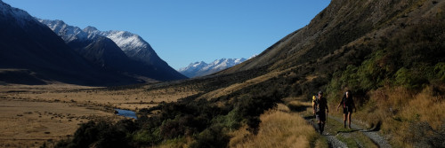
- the route has changed between Lake Tekapo and Lake Pukaki - it now follows the Tekapo Canal (though this can be closed at any time for work requirements or in high winds - there is a road alternative shown in the Trail Notes)
Walkers are reminded to always keep a close eye on the Trail Status page.
Anything that arises resulting in route closures, diversions etc will be noted as they happen on that page.
A new route will open in Helena Bay (Northland) in the next few weeks - a new map and Trail Note description will be posted on the website, and noted on the Trail Status page.
Te Araroa Trust requests that when walking on road edges or in commercial forests, please wear some form of hi-viz clothing (pack cover and/or vest) and don't wear headphones.
Te Araroa Trust is a charitable trust that relies on donations and philanthropy to give walkers this amazing experience. The Trail Notes and Maps cost the Trust a significant amount to update annually and are supplied to walkers at no charge. Walkers are asked to make a donation to Te Araroa Trust to support the ongoing work - Te Araroa Trust suggests donating an amount similar to the cost of boots, tent, pack and other such "necessities".