News and media
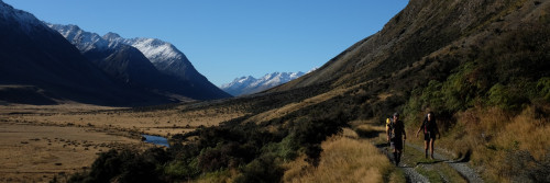
The Whangamarino Track
The new Whangamarino Track heads directly from Mercer south to the old Te Teoteo Pa. Along the way a walker will get good elevation above the Waikato River to the west and to the east, for the military-minded, glimpses of an old battleground. This is the area where in July 1863, colonial troops crossed the Mangatawhiri River, and advanced into the territories of Waikato Maori.
.gif)
At the start of the Waikato campaign, General Cameron’s men established three Koheroa Ridge redoubts (marked 1 in this historic map). Five hundred colonial troops under Cameron’s command then advanced along the inland crescent of Koheroa ridges, skirmishing with Maori (dotted areas), over-running Maori rifle entrenchments(2, 3, 4, and 5) and two thirds the way along the ridge massing for a charge (the black square). One trooper was killed and 10 wounded. Maori lost 30, including their chief, Te Huirama. By 14th August the British occupied Te Teoteo pa that Maori had used as a base (6) but had then abandoned to take up new defensive positions at Meremere. The new Maori entrenchments there were formidable and included old ships’ guns with a field of fire across the river.
Cameron’s men built the Whangamarino redoubt alongside Te Teoteo pa, and during the 3-month wait for the arrival of Australian-manufactured gunships and a further advance up-river, shelled the Maori position, 2.5 km distant.

(1).gif)
October 29, 1863: 40-pounder Armstrong guns at the Whangamarino redoubt fire on Maori entrenchments at Meremere. Below, the Whangamarino tributary joins the Waikato river. (Charles Heaphy watercolour, Alexander Turnbull library).
The new track does not follow the old battle route, which is now farmland, but parallels the river and transport corridors. It’s 3 kilometres long, hilly, and crosses two swamps in a 90 minute traverse. It’s tramping standard, and at the south end connects to the Department of Conservation’s Whangamarino Redoubt Access Track.

The new trail has good elevation above the Waikato and the road and rail corridors that squeeze beside the river.

The trail overlooks Motutawa, an island on the river . . .
(1).gif)
. . . and overlooks also this shaped hill, not part of the main battle for the Koheroa ridges, which took place further east, but fortified by the British to command the surrounding land, and the nearby Te Teoteo Pa.

From Auckland, take the Mercer exit off the motorway and keep bearing left onto Koheroa Road. The new track starts off the end of Skeets Road, 100 metres east along Koheroa Road. At its southern end, the new track connects to DOC’s Whangamarino Redoubt Track accessed from Oram Road, and from there leads away to Mercer (as above). Thanks to the Perry Foundation for financing this latest addition to the New Zealand walking track, to Transit New Zealand, and, as the mana whenua on this land and for their help, thanks to the Nga Muka Development Trust.