News and media
Routefinder's Diary
|
Routefinders work to refine tracks for Te Araroa. They're active in Northland, Rodney, South Auckland, the Waikato, the Manawatu, Southland and Otago. Winter closes down track construction, but the route finders work in the dark months to prepare for summer. Where routes cross public estate, the routefinders talk the possibilities through with DoC staff, and where alternatives exist, test-tramp them. Here's the report of Michael Pullar of Te Araroa Otago Trust after he tramped alternative routes between Lake Hawea and Lake Ohau spring 2004, and late autumn 2005. On the map below, the river bi-secting the various routes is the Ahuriri. On low flow days it's wadeable, but DoC has discussed with Michael a possible footbridge near the river's confluence with Snowy Gorge Creek (3) and there is an existing bridge at the southern end of route 6.
The route is as discussed in Moir's Guide North (2000 Ed) and as indicated on topo map G39. All references are to that map. There are currently 20 metre marginal strips running up both sides of the Timaru River, which links with conservation land to DoC's Top Timaru Creek Hut, some 18 km up stream. Lake Hawea Station borders the true left bank of the river and Dingle Burn Station borders the true right bank. Dingle Burn is currently going through the tenure review process and, assuming it completes, around 7 000 hectares of land is likely to be added to the existing Conservation Area around the Timaru River. Judging from the LINZ web site, Lake Hawea Station is also in tenure review. However, it is at an early stage and no activity has been registered since 28/8/03. |
|
 |
As to the route up the river, there is a car park at the Timaru River Bridge. From there, there is a partially marked DoC route that has not been maintained (since the early 1990s according to Moir's Guide). It is now in poor condition. For the first 40 minutes a track of sorts follows the river. It's mostly overgrown and sometimes non-existent. During this period I had to cross the river about a dozen times. These crossings were straight-forward enough with the water at the upper thigh depth. (I'd been to the start of the route last Easter and then the water was only upper calf deep). The water was a milky colour due to snowmelt and its bed was obscured as a result. After a few crossings, my initial unease about this abated. For the next 20 minutes the valley gorged to some extent and much of the travel was directly along the river's edge, often over scree slopes formed as a result of slips to the river edge. Up until then, it had been mostly beech forest on the true right and rugged scrub country on the true left.Travel continued over open river flats to Junction Hut (Dingle Burn Station) but likely to become under DoC administration as a result of tenure review). |
|
The DoC sign at the start of the route estimates 1.5 hours for this leg, and I found that to be accurate enough. I continued for another 45 minutes to point 242 244 where there was a clearing on the true left which would have made a good camping spot. There was a clearly evident DoC marker here, from which the route led straight up from the true left to a terrace as discussed in Moir's and as marked on the map. Travel was then in the open apart from the area around the first 2 side streams, which were heavily gorged and awkward to negotiate, as they were steep and overgrown. (Much of this route would have been outside both the Conservation Area and the marginal strip so we'd need to check what legal basis, if any, DoC had for marking the route here). Once at the tree line the route continued above the river through beech forest (as it did all the way to the sub alpine tree line). It was then easily lost and the going was slow (due to re-growth and windfall). Eventually, I lost patience and came down a steep slope to the river at about 256 247. It didn't prove to be a good move as travel up the river was difficult at its present level. Notwithstanding, I eventually made it through to 269 250 which is where Moir's Guide says travel up the river for a period is an alternative to following the poorly marked route. I stayed with the river and it remained challenging. Particular difficulties arose on 2 occasions with the river gorging and, on one of those, I had to try 3 different routes before finding a way through that I was reasonably comfortable with. At 5 pm I found a small campsite on the true right at 304 269, where side streams come into the river from both the true left and the true right. I stayed there for the night. There probably would have been enough time to get right through to the Top Timaru Creek Hut. But, by this time, I was pretty tired and struggling to maintain the concentration the route was demanding of me. Sand flies were a nuisance until dark. |
|

|
|
The next morning I crossed the river and immediately picked up the marked route again. This time I was determined to stick with it and managed to do so all the way to the tree line. I took some detailed notes but, basically, travel was within the marginal strip and/or Conservation Area and the route was slow but viable. Care was required at times and it took 2 hours 40 minutes to cover the 3km distance. There were 3 or 4 river crossings but the route was almost exclusively on the true left. From the tree line, an hour's open travel led to the hut with numerous river crossings in the process. In total, if you take out the overnight stop, it took me 9 hours and 10 minutes to get from Junction Hut to Top Timaru Creek Hut. This compares to the DoC estimate of 4.5 hours, which would be quite achievable with a maintained track in place - impossible with the route in its current state. Top Timaru Creek Hut is a 4-bunk hut, which is in good condition. There is no toilet but a shovel is provided (the rocky soil makes digging hard work). Water is available from a nearby creek that runs into the Timaru River. I ended up calling it a short day and stayed the night here. According to the hut logbook, I was only the second person to stay here since April last year. The other person was Mathias Mard who stayed there on 21/2/04 and who featured in the last Te Araroa newsletter. Above the hut there is a farm track running to the valley head then up and over the 1680m Mt Martha pass and down to the Birchwood Rd. This entire track is on Longslip Station which also currently in tenure review. Public access easements are proposed over the whole distance. Longslip is in DoC's Canterbury Conservatory. I spoke to someone there and was told that, all going well, the leaseholder is 6-9 months away from signing the substantive proposal (which is the point of no return for him). |


|
Note: little on no progress has been made since with the Longslip tenure review. However, unless and until that occurs there is no legal right of access over this part of the route. I telephoned the leaseholder to get permission. He gave it without hesitation. Travel over this part of the route would normally be straightforward with no track development required. My progress was hindered however by snow, which was expected at this time of year. It took me an hour to get to the valley head and then another hour's slog up to the pass. Snow slowed me a little but I managed to skirt around most of it on the way up. On the northern side of the pass there was much more snow and I had to travel in it for about half an hour, using the map in the process as the track was not evident. |
|
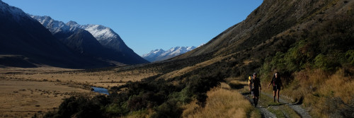
 Timaru Creek - looking south from the pass |
Although it was still only mid morning the snow was very soft and, without the advantage of down hill momentum, I don't think that at the time it would have been possible to travel the route in the opposite direction. Down at the snowline the track was easy to pick up again. It followed a stream and I continued on it down the valley to the confluence with Avon Burn. I followed this stream out to Birchwood Rd, taking a short cut along the fence line shown at 449 369. (The proposed public access easements follow the same route). I reached the road 6 hours after leaving the hut and covered around 20-km in the process. |
|
On the other side of the Birchwood Rd exit point there is a DoC signposted route over to the Ahuriri River, which is less that 1 km distant. From there, if the river can be crossed, there is legal access up the eastern branch of the Ahuriri and over to Ohau, the route walked and described by Geoff Chapple in his book (Route 6). If the river was too high to cross this would necessitate a 10-km detour east to the existing bridge. I walked along Birchwood Rd for about an hour before a car came along, picked me up, and took me to Omarama. I had prearranged transport back to the Timaru River car park. When I arrived back there it was clear that the river's volume had increased considerably. This was due to snowmelt caused by the strong, warm westerlies that had been blowing for 3 days. I'd suspected this had been occurring on the way up, as the river didn't diminish much, notwithstanding passing a number of significant side streams. Concluding thoughts The altitude of the Mt. Martha pass will always create issues with snow until late spring, at least. I don't really see this as a problem, however, as the Twain Track will be out for the same time frames for the same reason. The real issue is perhaps the river itself as, even with track development, it still comes into play. However, for summer and autumn, our natural tramping season, normal flows are such that this is unlikely to be a problem. All that would be needed is a favorable extended weather forecast from Ohau (or Hawea if you're going the other way) and an extra day's emergency food. This should allow for anything unforeseen to be sat out in all but extreme circumstances. Once the Dingle Burn tenure review completes, possible routes further west will open up. In this respect, Moir's Guide describes a route from Top Timaru Ck Hut to Junction Hut via the Moonlight and Roses Hut. However, this is over high, exposed and rough country, and would add a day to the trip. Further west still there would be easier travel down the Dingle Burn itself, but this would add significant distance to the route, perhaps taking it out of the range of what is achievable in a single leg for trampers of average ability? Hawea to Ohau - Dingle Burn route: 21-24 April 2005. Moir's Guide recommended travel via the river to Bush Hut, in preference to the overgrown high water route, so I took that. It was nearly 40 minutes before I had to get my feet wet. After that it took an hour to get to the hut with frequent but straightforward river crossings along the way. The Bush Hut register included a February entry form Warrick Hope of Hamilton who was in the midst of an 8 day section tramp heading south on a route he described as Te Araroa , though instead of continuing down Dingle Burn he took a high route over to Top Timaru Creek Hut. He didn't say how he planned to exit from there. The register also contained a discussion about a substantial slip further up Dingle Burn, about halfway to Cotters Hut. I'd spoken with DoC about this before the trip and was advised to take extreme caution. Of those who had mentioned the slip in the register, some had turned back. Others had crossed it (or crossed part of it and then had gone down the creek in the middle to the river). One carefree soul said he'd crossed without concern. All the others said they felt uncomfortable doing so. |
  |
From where the track ended below, it looked as though the top of the slip was at the ridgeline but this was far from the case. The situation is as appears on G 39 with significant space available. I sidled across somewhere in the middle, high enough above the slip that I couldn't see where the forest ended and the slip started. At the same time I was still well below the ridgeline. Once I thought I was safely across I sidled down through fairly open forest and met the marked track again about G 39 314 413. Other than windfall there were no obstacles along the way. I later discussed with DoC the possibility of realigning the track before the slip so that it travels up towards the ridgeline from near .763 (there appears no impediment to this on the map) as long-term solution to the problem. They agreed that may be the best solution and are to look into it and if feasible hope to have done the work, and the rest of the track cleared, within a year. |
|
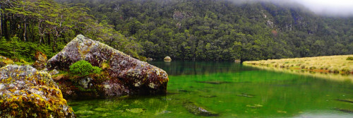
View from pass between Dingle Burn and Ahuriri Valley |
Despite a lack of maintenance, the route beyond the slip was in surprisingly good nick. There was regular windfall to negotiate but the trail was easy enough to follow with care all the way to Cotters Hut, a 2-bunk charmer situated at the edge of a large grassy flat that is used as a landing strip for fishing parties. A number had boasted in the hut register of bagging in excess of 50 trout. (There, the secret is out) I passed Ben Avon Hut along the way. Euphemistically you'd describe it as "rustic". .Someone had written a warning inside the cover of the register that " sleeping bags must be hung up otherwise rats will nest and die in them ". I believed this as you could hear rats rustling about in the 10 minutes I was there. Some took a more appreciative view of the place, with one writing, "this hut has true High Country Character". Another message (my favourite) said, "Hooray to find an unsanitised hut full of history. Many happy nightmares OSH!" Needless to say, not many folk have stayed at Ben Avon Hut but I guess you'd give it consideration if your life was at stake. |
|
About 500 metres beyond Ben Avon Hut I reached a thick line of Matagouri, which, as Moir's Guide says, should be crossed at the 700-metre contour. There was a faint ground trail there but it was horribly overgrown and I was reduced to crawling on all 4s a number of times to get through. Even then I was in a pretty scratched up state. |
|
 |
Next day, my third with great weather in a row, I crossed the Ahuriri River and walked down the true left to the Snowy Gorge Creek confluence and then travelled up to Snowy Gorge Creek hut. The route is unmarked but is easy to follow through open country that gets more interesting as you go. The Hut has 5 bunks and is in good condition. It's the only one I came across without a fireplace. This made sense, as there was no wood around for many miles. I arrived at 1 pm and called it a short day. |
|
There was a southerly change in the night, which brought about a few centimetres of snow. It was breezy in the hut but water proof save for a small pile of snow that accumulated through a crack in the door. The weather was still rough when I woke up in the morning. I'd initially intended to exit to Ohau via Dumb-Bell Lake to the Freehold Creek exit. I would have climbed above 1900 m in the process but would have remained on Conservation Land throughout. To me it seemed an option to make this the official Te Araroa route in good weather with the Maitland becoming the official fallback route in bad weather (the saddle between Snowy Gorge and Maitland is the high point on this route at around 1350 m). |
|
|
|
True to my theory, with strong southerlies and snow, I changed my plans and exited via the Maitland Valley. The weather abated to some extent but I was pleased to have some shelter when enter beech forest lower down. From there a well marked track follows the river down before the track climbs steeply across scree slopes to a 4WD Track that exits to Lake Ohau across Ohau Station. From the Lake Ohau Road it's an 8-km walk to Lake Ohau Lodge, a great place to stay after a few nights out. |


|
After thoughts I'm still concerned about the extra travel involved to link the Dingle Burn into Te Araroa but it may well be the better alternative to Timaru Creek. My concern with the latter is that it's vulnerable to rising river levels and may result in south bound trampers testing fate by pushing on towards the end of a long section when they're low on both food stores and energy levels. In addition, Dingle Burn is a little more scenic and the pass at its head is lower than Timaru Creek's. In my view, however, neither of these 2 points outweigh the advantage Timaru Creek has through being the more direct route. Geoff Chapple has recently suggested a third route over Lake Hawea Station. It would involve travel up John's Creek, then along the ridge above Timaru Creek before descending to the upper valley around Top Timaru Creek Hut. From there it would be out the same route I took over to the Ahuriri River. I'll discuss this with DoC as well as other possibilities through Lake Hawea Station via its tenure review process. Another good tramp will hopefully result next spring. |