News and media
Our 2008 year
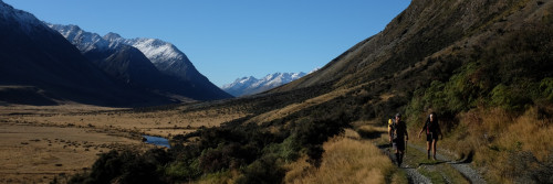
This year was our best yet for the number of tracks opened along Te Araroa’s' route – 14 of them, totalling 134 km.
In 2007 we completed 75 km of new track. In 2008 we completed 134 kilometres. They were -
|
Makahika-Mangahao
|
Manawatu
|
February 08
|
15 km
|
|
Arapaepae
|
Manawatu
|
February 08
|
7 km
|
|
Puhoi Lookout loop |
Auckland
|
February 08
|
1 km
|
|
Motatapu
|
Otago
|
March 08
|
29 km
|
|
Long Hilly / Ports Race |
Southland
|
March 08
|
14 km
|
|
Onekainga
|
Northland
|
April 08
|
6 km
|
|
Anakiwa track extension |
Marlborough
|
July 08
|
2 km
|
|
Waikanae-Paekakariki
|
Wellington
|
August 08
|
22 km
|
|
Mangawhai Cliffs |
Northland
|
September 08
|
3 km
|
|
Waitomo-Te Kuiti |
Waikato
|
November 08
|
11 km
|
|
Mallington
|
Auckland
|
December 08
|
2.5 km
|
|
Kimptons Track
|
Auckland
|
December 08
|
2.5 km
|
|
Feilding –Bulls
|
Manawatu
|
December 08
|
15 km
|
|
Mackerel Forest
|
Northland
|
December 08
|
4 km
|
|
TOTAL 134 km |
|||
We made good progress on the scoping and setup – though not necessarily the funding – of many other tracks throughout the country. The most spectacular of these in the North Island is the proposed Paekakariki Escarpment track north of Porirua. In the South Island the purchase of St James Station and its conversion to a Conservation Park means that some 24 kilometres of track can now be put in place down from Waiau Pass to join with the St James Walkway.
Our regional trusts worked to open many routes during the year. We often had help from councils, and importantly, where we’d previously funded the track across DoC estate ourselves, 2008 marked the first full year where DoC itself took over this task. The department was voted $3.8 million specifically to achieve the route across its estate. It tackled two construction projects this year, and it also signed up 340 kilometres of Te Araroa’s route across existing DoC tracks. That was almost half of the 827 kms that needs signage, a great effort.
DoC knows our December 2010 deadline for opening the track, and is trying to ensure its part of Te Araroa will be complete. In 2009 it will spend around $1.5 million on taking the track through the estate.
That still leaves our largely volunteer organisation with plenty of money to raise –and plenty of scoping and construction and signage work to do outside the conservation estate. By regions, the work done this year was –
In March, Te Araroa Southland Trust opened the Long Hilly track up to the old holding dams above the alluvial Longwoods goldfields. The associated 14-km Ports Race Track through to Cascade Road, though rough, was also de facto opened at this time though in 2009 DoC will work to smooth this route. The Ports Race Track piggybacks on the maintenance path that ran alongside alongside the Chinese-built race. DoC plans 28 small bridges over the race’s overflow channels.
Southland DoC also plans to spend $100,000 marking out the next northward leg from Cascade Road to Bald Hill Road then $90,000 for the section Bald Hill to Merrivale Road.
Outside the DoC areas, Te Araroa Southland Trust scoped a route – not yet legal - through Rayonier's three forests, and gained all land-owner consents across the 4-km of farmland from Colac Bay through to More’s Reserve. Once this track is put in, it’s an easy toddle down to Riverton. During the year Te Araroa Trust helped secure a $50,000 contribution from Invercargill District Council, to assist Te Araroa’s Invercargill-Bluff leg. Southland Regional Council has itself guaranteed $50,000 for this project.
A further $155,000 of the DoC money will fund a suspension bridge on the Hawea River. The Upper Clutha Trails Trust has raised the rest of the money for this 10-km track, and work begins in 2009.
DoC built and opened the Motatapu Track in 2008. This trail was conceived when Te Araroa Otago Trust picked up news of the sale of Motatapu Station to Eileen and Mutt Lange in 2004, and Te Araroa Trust then pressed the case for access with the Overseas Investment Comnmision. Eileen (Shania Twain) and Mutt later agreed to pay for this Te Araroa section and for two huts en route. DoC completed the trail beautifully by insisting on marginal strip access as the trail left Motatapu Station to exit down the beautiful Fernburn Stream, on Alphaburn Station.
Otago councils have also directly contributed to Te Araroa. The track Wanaka – Glendhu Bay has two gaps. Each one has a budget, and work is expected to begin soon on the Otago Regional Council section (from the end of the Millennial Track to Damper Bay – 2-km) and the Queenstown Lakes District Council section (Damper Bay to Glendhu Bay – 5-km that may include some blasting, or cantilevered boardwalk). The Otago trail will be gradually improved over the years, as will happen in all regions. Still, Otago can now claim that once the two Wanaka links are opened, Te Araroa's route from north to south of the province will be complete.
The route through Mesopotamia Station was secured under Crown Tenure Review, though the track is not yet in place. The route through St James Station was secured as a result of the Government’s purchase of the entire property. Canterbury DoC has yet to mark this track down from Waiau Pass, but it’s already an informal track, and now it’s legal. The Canterbury Conservancy, as we last heard it, was preparing to mark up some 85 km of new track that Te Araroa route finders in the field had marked as part of Te Araroa’s route.
We don’t have a Nelson / Marlborough Trust. It’s our only significant regional lack, but Te Araroa’s route through Marlborough / Nelson is 80% (224 km out of a 282 km total) on existing DoC tracks, mostly now signed with TA logos. Also, the most urgent non-DoC route – from Anakiwa through to Havelock, is being tracked by the Link Pathway Group, which has already put in significant sections of trail alongside Queen Charlotte Drive, and along a coastal section of Mahakipawa Arm. Te Araroa trust, using money from the Mayors Taskforce for Jobs helped fund this group’s work and during the year it put in a 2 km track extension down from Tirimoana (just south of Anakiwa) towards the junction with Queen Charlotte Drive. The Marlborough District Council has agreed to pay for the one essential bridge en route.
Te Araroa Wellington Trust opened the 22-km Waikanae-Paekakariki section – one of Te Araroa’s linkage-style tracks through peri-urban terrain. As well, the trust went entirely bush to scope the Oriwa Ridge between Waiopehu Hut and Otaki Forks. This route is in the Tararuas, but one ridge further west, making it safer than Te Araroa’s previous route, that was deep within the range. Oriwa is being prepped for a DoC bid.
Negotiations are also continuing to shift part of the Wellington-Porirua track from Ohariu Valley Road onto the parallel off-road route along Best’s Ridge, an exhilarating (i.e. open to the famous wind) route that in time will be part of Wellington’s outer town belt. We’ll let you know if and when this occurs, but meantime it’s strictly private property. The trust also initiated the 7-km route along the Paekakariki Escarpment, and has secured most of the land consents. This track has been professionally assessed and will cost around $500,000.
Te Araroa Manawatu Trust has been highly active since its setup in November 2004. In February 2008 the trust, together with DoC which helped this track along with expertise and funding, opened the 15-km Makahika track. By reputation, the Makahika Valley has the densest population of morepork in the country. Then Te Araroa Manawatu Trust opened the 7-km Arapaepae track connecting the Makahika exit through to Levin.
In December the trust finished marking the route between Bulls and Feilding. It is presently trying to overcome a farmer’s insistence that a deer fence blocking the paper road between Feilding and Palmerston North should stay. When that’s resolved, they’ll finish marking up this route. With these bold strokes, Manawatu has now almost finished TA’s through route, and is aiming to be the first region to complete.
Te Araroa Whanganui Trust is our newest regional trust – just over 12 months old. It has scoped south of Whanganui 20-km along an old rail line. The trust has been speaking to farmers en route, and believes this exciting route might be a goer. Meantime the Whanganui River itself has gone onto our browsing maps as an open section with the alternative, for those travelling south to north, of using the remote River Road. We’re working to provide more detail of the river route, with suggested stop points and the proper cautions for canoeing a big river. The river can be dangerous, but will be one of TA’s most memorable sections. The present scoping of the old rail corridor, with tunnels, might well be another. In 2009 we’ll begin to tackle the northern part of Te Araroa’s route through Whanganui – from the central plateau and the National Park settlement down to Pipiriki.
Te Araroa Waikato Trust’s biggest achievement was the completion – except for destination signage which is still being designed – of the Waitomo Caves-Te Kuiti track, 12 kilometres in all. The track was a major enterprise. It involved a swing bridge across the Mangapu River, and $50,000-odd of a specially raised and cross-drained track through the buttresses of the Pehitawa Forest, a significant Kahikatea remnant.
Partly as a result of the Waitomo-Te Kuiti effort, Te Kuiti Rotary grabbed the baton, and has now tracked most of the way south of Te Kuiti up the Mangaokewa Stream to join with the track we put up the stalactite-hung Mangaokewa Valley in 2005.
Elsewhere, DoC took over the project we’d worked on for two years to boardwalk across the summit of Mt Pirongia. This is DoC estate, and we’d previously spent $170,000 on this work. Now DoC – or the contractor it employs – has a budget to complete the work – expected in 2009.
Scoping work has started on a connecting track from Mercer and Meremere. This track goes past significant Land Wars history south of the Mangatawhiri River – New Zealand’s equivalent of the Rubicon, for when Cameron’s British troops crossed this tribal boundary in 1863, it was seen as a British declaration of war on the Waikato tribes. You can still see the redoubts, including the high ground where Cameron set up his Armstrong guns and shelled Meremere. There was heavy fighting around here, and consequently wahi tapu areas. The Waikato trust is liaising with Tainui as to Te Araroa’s route.
North Shore City and Auckland City have adopted the trail, and Manukau City is spending close to $1 million to complete the trail originally begun by our volunteers up the Puhinui Stream. The Puhinui section ends at Totara Park, and Te Araroa Auckland volunteers have done all the negotiation onwards from there, recently completing construction of the 2-km Kimptons Track, and successfully negotiating from there – though the track is not yet in place – a route into the Hunuas, the Mangatawhiri Conservation area. South of the Mangatawhiri Conservation area our team put a track through the Mallington farm this year, but it presently dead-ends and consequently we have not yet put in destination signage.
Te Araroa Trust put in place a 6-km track at Onekainga thanks to the generosity of local farmers. The Onekainga track presently dead-ends too, but not for long. We’ve begun work to take the track on to Helena Bay. Final completion here awaits a sub-division consent.
We consulted extensively with Maori and got permission to go from the Waikare Inlet up what’s legally a Maori road and from there into the Russell State Forest. Work should begin on this Papakauri track this summer.
Our Matapouri Bush Track had to close because of landowner unease at the south end, but we’ve worked hard to get an alternative exit – and a contractor is about to put this in place. We’re having trouble also putting the track through the peninsula south of Ngunguru, so meantime we’ve put in a diversion track through Mackerel Forest.
Northland DoC is undertaking an extensive construction programme on Te Araroa’s behalf this summer, and so we worked during the year to smooth the way for their people, ensuring exits and entries onto DoC land and through private forestry land were as legally secure as possible.
Sir Edmund Hillary the first man to climb Mt Everest, the world’s highest peak, died January 11 this year. The adventurous life of this great New Zealander is well enough known to need no repetition here. His charitable work is also well-known, particularly in support of the Nepalese, but amongst his many activities he was a patron of Te Araroa Trust, and our great supporter, opening two of our tracks. The stone at the beginning of the Meremere-Rangiriri track, opened by him in 2000, and the carved macrocarpa slab at the head of the Tamahunga track, opened by him in 2002, have taken on a special meaning.
John Pawson, chairman of the Upper Clutha Trails Trust was killed when he fell 600 metres on Mt Aspiring, November 27. John was a co-founder of the outdoors adventure chain Kathmandu, vice-chairman of Otago Federated farmers, and ran a lodge in Wanaka with his wife Meg Taylor. Under John’s leadership, the UCTT had ironed out property questions for the 11 kilometres of track from Lake Hawea township to Albert Town, following the Hawea River, and had secured a budget for the track which is expected to complete in 2009.
Warrick McCallum of Te Araroa Southland Trust died late August from cancer, aged 74. With Mayor Frana Cardno he’d cut the ribbon on the Long Hilly track in March, fulfilling a dream of good walking access within the Longwood Range. Warrick constantly, and often mischievously, prodded those official organisations tasked with protecting the public weal. He was unstinting with his own efforts. He set up Riverton’s Pestbusters which tackled magpies and possums and rats within the local More’s Reserve. He was on the committee that put in place the astonishing “Te Hikoi Southern Journey Riverton Museum” and founded the Longwoods Track Committee that later became Te Araroa Southland Trust. At the DoC conservation awards this September he was posthumously named Southland’s top conservationist.
Arthur Dunn was out on a bait run August 18 within the popular “Dunn’s Bush” north of Auckland when he had a heart attack. A SAROP team found him within the forest later that night. Arthur was 69, and a well-known conservationist. He and wife Val donated two bush reserves to the nation, and they supported many causes. In 2006, Arthur put in an easement across the back of his farm to take Te Araroa down from Moirs Hill, towards Puhoi.
We changed our website over the year. Browsing maps went up for the first time. These were for people interested in the general trail route. A second category – “Trail notes” – is for trampers. As we’ve put together our track descriptions over the years, the style of our information brochures has been diverse. We need to standardise our descriptions, and so we’re working on a standard track template that will automatically bring up the relevant Google map. The template will have specified sections – for example a section that’s a brief description of the track itself, another that gives track standard by pictogram, another that lists hazards, and so on. There’s still a lot of work to be done here.
Te Araroa’s opening is two years away. We built 134 kilometres of track this year, but over the next two years must complete another 350 kilometres. If you do the maths, our rate of track openings in the two years ahead has to be still faster than this, our best year. DoC estate makes up around one third of the distance remaining and DoC will handle the route there. Elsewhere the job falls to Te Araroa Trust and its regional trusts, boosted by whatever co-operation we receive from councils and landowners. To complete the trail to a good standard we still need around $6.5 million for track budgets. Over the past few years councils have been generous in their support of track budgets, and we should make special mention of the ASB Community Trust which funded all the tracks we opened in the north.
Councils are now showing a tendency to cut back on park and recreation budgets, so it may be harder graft now to get the track budgets. The most critical money we need therefore is the yearly $40,000 for administration and project management. This primary funding enables us to apply for track budgets from the official bodies, to make presentations to councils, to pay for travel to scoping sites and so on. The whole Te Araroa enterprise revolves around this effort, so if you can give us $200, we’ll give you a virtual plank on our boardwalk – see the website button - and you'll be contributing to a great enterprise. At this stage every $200 is a great help.
We don’t have the exact figures, but it’s safe to say that over the past eight years Te Araroa Trust and its regional trusts have opened more new walking access than all the official bodies combined. Much of Te Araroa is walkable right now, and the challenge ahead is the last 350 kilometres that secures the through route. We’ll keep at it, and thank you, our readers and donors for supporting this effort. We’re on our way to that December 2010 opening.