News and media
Mangaokewa Trail open - sort of
The 15-km Mangaokewa river trail has no destination signage yet - but we've decided it's open anyway. Click these links to
download the Mangaokewa Trail brochureor
Mangaokewa Trail map.
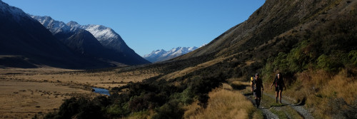
So - go a couple of kilometres southeast of Te Kuiti on Highway 30, and turn in under the railway viaduct to Mangaokewa Reserve.
The new trail starts at Mangaokewa Reserve and follows the true left of the Mangaokewa River, exiting at Mangaokewa North Road.
Or, to start from the top end, drive 18 kilometres up Highway 30, turn left into Mangaokewa Road, make another left about 2.5 kilometres in, then follow the metal road - Mangaokewa North Road which rapidly dwindles into a track with a happy grass median - to its end.
As to the trail itself - the stiles are in place, also the orange markers, a bridge across one big gut, and corduroy swamp crossings. We're not marking this trail up with destination signage right now because we're trying to take it through to Pureora Village, another 15 kilometres or so south-east of Mangaokewa North Road. Seems silly to go to the expense of putting destination signs for this first 15 km, then have to re-do signage once the route through to Pureora is finished.
So if anyone wants to walk this section meantime - go for it. You'll be helping us tramp the trail in, and legal access is okay right through to the Mangaokewa Road end - five hours tramp away. Be aware though that you'll need transport out from Mangaokewa North Road - it's a long way from anywhere, and hitchhiking would be difficult. There's zilch traffic.
If you're starting at Mangaokewa Reserve be aware that a track leads away on both sides of the river. If you're after our track then don't cross the little swing bridge. A signposted track leads away over the bridge, and it's a good track but it deadends a couple of kilometres upriver. Our track is on the true left of the river i.e. - as you face upstream, it leads into the bush on the right hand side of the river.
The first 2.5 kilometres of bush is groomed and made fairly predator free by the Mangaokewa Reserve Trust which has also released native bird species in there, tom tits and others. You pass by a huge kahikatea, and get glimpses of limestone stalactites hanging from the far edge of the gorge. The trail then crosses a fence we put in to keep sheep out of the reserve, and breaks into farmland. Around about here, the primeval forest on the far side of the river - the unfarmed side - is one of the best sights on the walk. The track stays on farmland, passes an abandoned dunny, glissades through totara groves and has some great picnic spots on the way through. It enters shady pine and eucalypt forest near the top, then emerges onto a farm track that takes you through to Mangaokewa North Road.
Tell someone you're going. No dogs please - you're crossing farmland, and the farmers have been very good about letting this trail through. No camping either. Near the top of the track you cross pine forest. Absolutely no naked flames or smoking in there. Wear boots - parts of the track are muddy. Track is BCA standard.
Thanks to Bill Griffiths, Michael Drinnan and Adam Turner, and track boss Noel Sandford for their work on this, also, for permissions, the local farmers and Global Forest Partners.