News and media
Access Through St James Station
The purchase of St James Station by the Government, announced on 8 October, brings in a critical South Island link for Te Araroa.
Te Araroa Trust CEO, Geoff Chapple, said the trust had sought the 45 km link through the station for many years.
"The new section will link Waiau Pass in Nelson Lakes National Park southward to the existing St James Walkway," he said, “That route is already used informally by experienced trampers but only with permission from the pastoral leaseholders, the Stevenson Family. It will now become an as-of-right route.
Now the route was legal, he said, Te Araroa Trust would be asking DoC to cut a better track down from Waiau Pass.
“The route runs now through a conservation area, and I’d hope that we can improve what’s often a very scratchy route through celery pine. But whether we get a team onto that or not, the new link significantly advances Te Araroa's goal for a legal route the length of the country by December 2010."
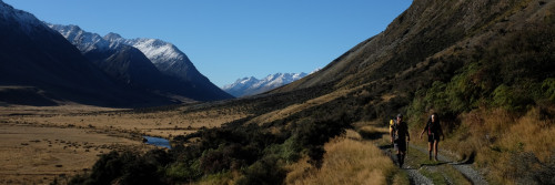
Te Araroa uses the well-known St James Walkway for part of its route across St James Station – only that half of the St James loop walkway relevant to Te Araroa is shown on the map below.
Te Araroa is route-standard only from the point at which it diverges from the Walkway. This route climbs to the 1,870-metre Waiau Pass on the station’s northern boundary which is blocked by snow and made dangerous by avalanche during winter and early spring. The route is not presently marked over much of its distance, and should be attempted only by experienced trampers, with maps, and in the right conditions. In general it’s a summer and early autumn exercise. Any trampers passing the Stevenson farmhouse – marked on the map – should give it a wide berth. By agreement with the Government, the family continues to farm the land for some years.
The relevant topographic maps are 260-M30, M31 and M32.