News and media
A track runs through it
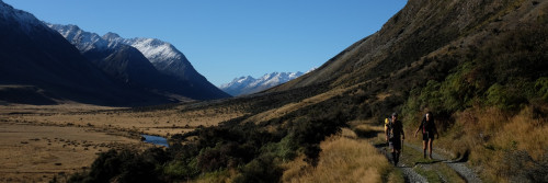
It’s South Island high country. It’s South Island history. And now a track runs through it. Te Araroa’s route across Mesopotamia Station and the Two Thumbs Range opened yesterday as part of the new Conservation Park, Te Kahui Kaupeka.
The latest 55 kilometres of track connects the Rangitata River valley in the north, to Lake Tekapo in the south, and emerges on Lilybank Road, about 10 km from Tekapo township. It’s a 2-3 day tramp.
Te Araroa Trust’s route through two pastoral leases – Mesopotamia and Richmond Station, was achieved during Crown Tenure Review. The trust’s Michael Pullar tramped an exploratory route through, and conducted the subsequent extended negotiations.
Mesopotamia was once owned by the English polymath, Samuel Butler. The surrounding mountains, wide braided river and hanging valleys give this remote part of the South Island its lost world character, and inspired Butler’s fantastical satire, Erewhon. New Zealand’s Colonial Secretary Dr Andrew Sinclair was drowned in the Rangitata River after surveying the wide braids of the river system with Julius von Haast in 1861. He was seeking a way through the river to get back to Butler’s homestead.
The park was formed and will be run by the Canterbury Conservancy of the Department of Conservation. Te Araroa Trust thanks DoC for its work in assisting Te Araroa get a good through route through the new park, and for setting the track in place in time for yesterday's opening. The map below shows Te Araroa’s route, but only part of the park. For a full PDF, go to - www.doc.govt.nz/publications/parks-and-recreation/places-to-visit/canterbury/te-kahui-kaupeka-conservation-park/
-1.jpg)