In January 2015 Mark Watson left sunny Cape Reinga to walk and photograph the length of Te Araroa. The journey would take him nearly six months, through constantly changing landscape, geology, and many different kinds of forest. He walked urban pathways, farm tracks, beaches, roads, regional and national parks and reached Bluff amid winter storms in July.
An introduction by Mark and a selection of photos from his book, Te Araroa – Walking New Zealand’s 3,000-kilometre Trail.
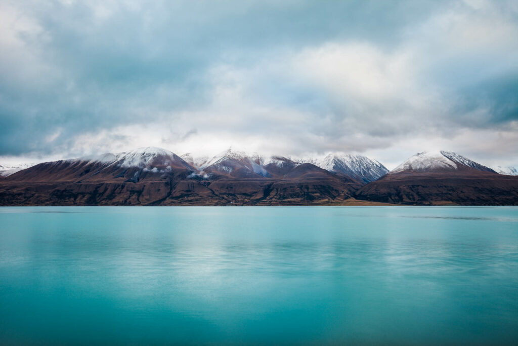
Every year from September to December a few hundred people shoulder packs and depart from Northland’s isolated Cape Reinga, their sights set on a 3000 kilometre journey south. Motivated, curious and perhaps daunted, these through-trampers will tackle a profoundly varied landscape as they traverse the two islands that make up Te Araroa trail. A land lying on the Pacific Rim of Fire, New Zealand is created by tectonic plate collision: our volcanoes, ranges and landforms are a consequence. This story of the landscape frames the Te Araroa experience.
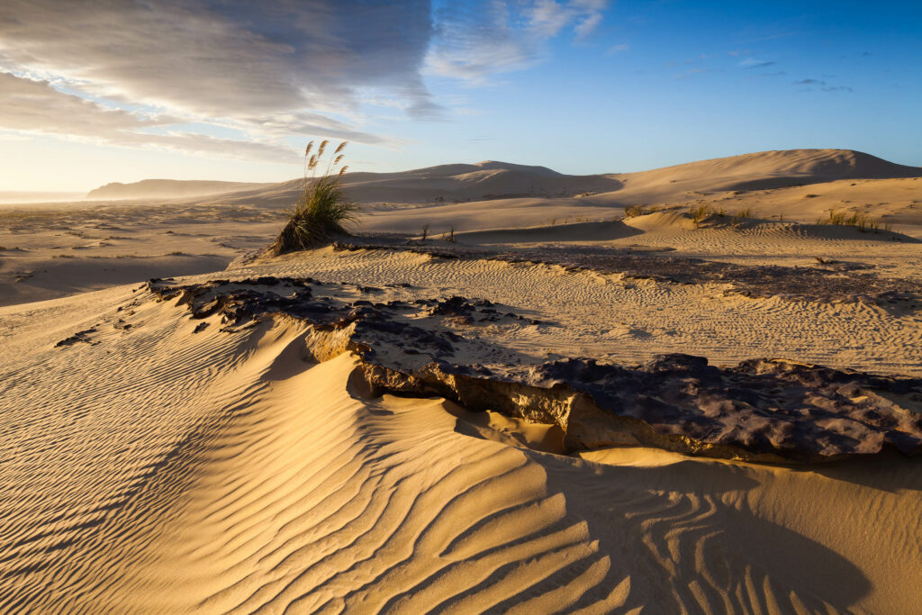
If you are beginning from the far north, Te Araroa starts with a mellow preamble along scenic, windswept stretches of sand, past Cape Maria van Diemen and over headlands where a view south can sometimes be snatched. The fresh air, hardy plants and unique colour and form of the landscape usher the walker into a new world, away from life’s usual routine.
Then comes the first test: Te-Oneroa-a-Tōhē/Ninety Mile Beach. Conditions largely dictate the walker’s experience, but camping in the sand, drinking swamp water, repetitious walking and blisters are common to most. With sand dunes to one side and the roaring ocean to the other, your view is channelled down the beach to a shimmering horizon. It can be blazingly hot, comfortable with a sea breeze or wind-blown sand might sting your legs. Some will love the walk and some will hate it. It’s said that if you can survive the beach and remain in good spirits, you can handle anything else Te Araroa might throw at you.
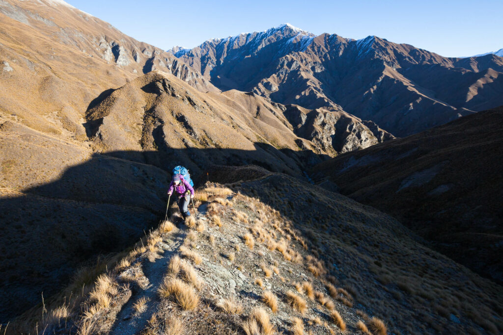
Those who continue will be rewarded by the myriad experiences and challenges – both physical and mental – that the trail delivers. They’ll be brought to their knees on the bad days, breeze over alpine passes on the good days and they’ll be entranced by Te Araroa’s pathway through New Zealand landscapes, towns and culture.
Generally, Te Araroa trampers are a mixture of New Zealanders, undertaking what could be seen as a Kiwi rite-of-passage, and self-reliant overseas travellers looking for a challenging way to see New Zealand – some of whom are veterans of overseas long-distance hikes. Many Kiwis ‘section walk’ Te Araroa, biting off a stretch at a time, as few have the luxury of time and freedom from commitments to undertake the trail as a through-tramp. Then there are the record-breakers, those walking the trail for a cause and people pursuing a new realm of life experience.
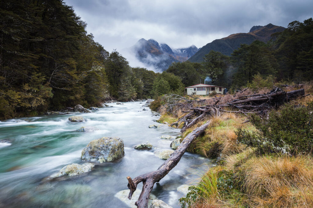
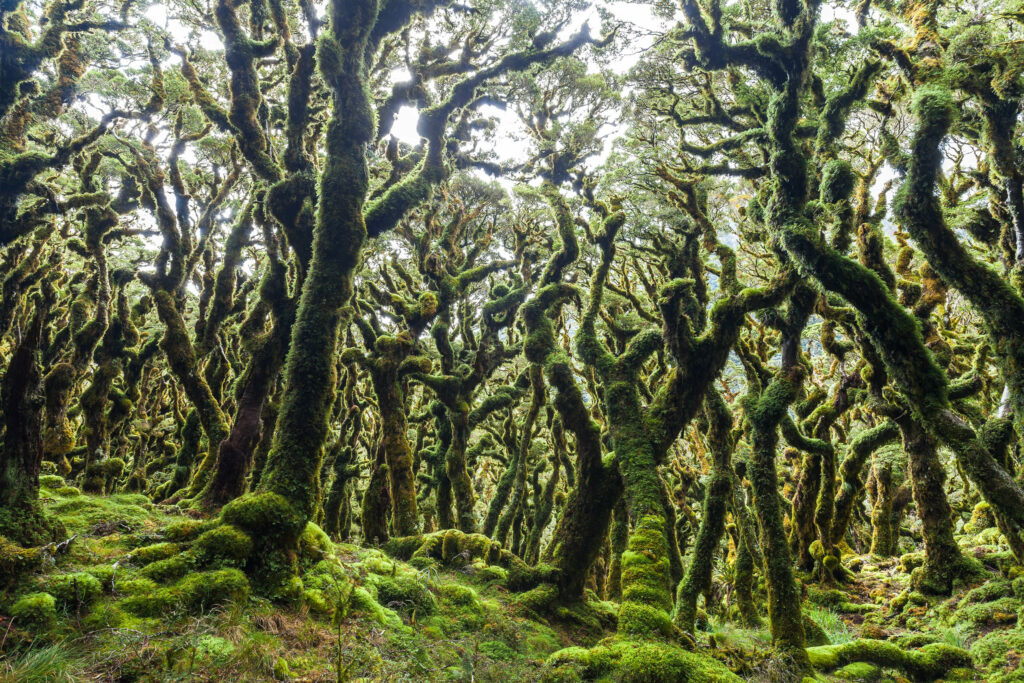
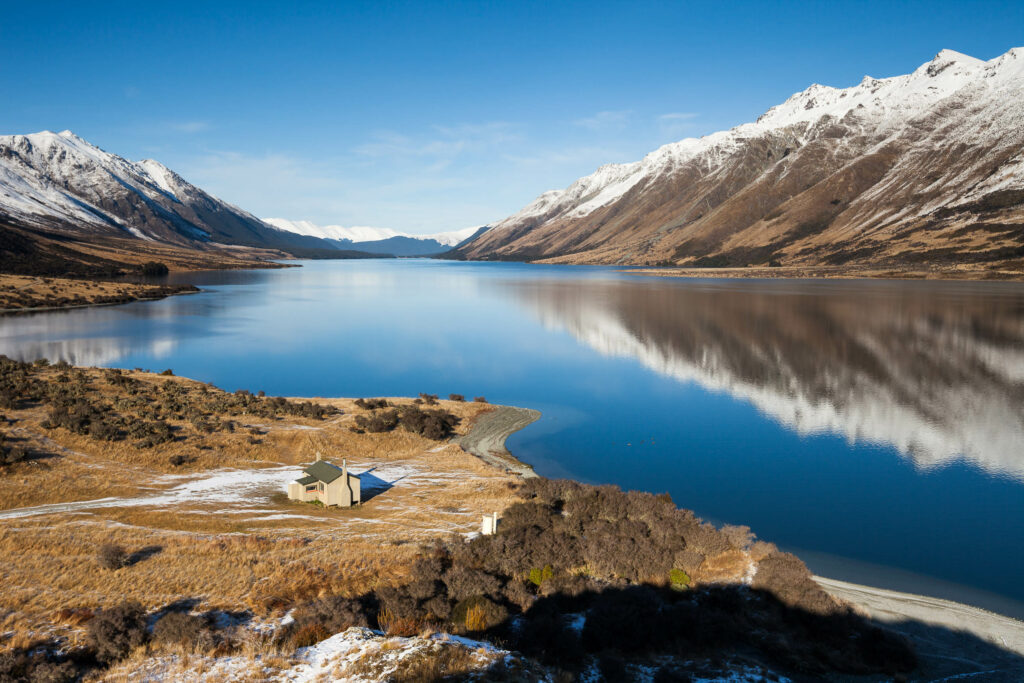
However it’s tackled and for whatever reason, trampers will experience a unique view of New Zealand. It’s a rigorous trek from tip to toe of a young country – the last significant islands on our planet to be peopled – that makes creative use of parks and forests, walkways, historic sites and the lie of the land to interconnect townships and points of interest, some well known, some obscure. If Te Araroa has one constant, it’s change: New Zealand’s subtropical north and colder south are latitudes apart, and reveal a varied geology and greatly divergent biota along the length of the islands – particularly noticeable by the many different kinds of forest encountered.
The form of the trail as we know it today is the result of the vision and determination of one man. Aucklander Geoff Chapple. An energetic author and journalist with a sparkle in his eye, Chapple took up where the government’s New Zealand Walkway Commission, set up in 1975, had left off. As Chapple recounts in his book Te Araroa – The New Zealand Trail, One Man Walks His Dream, Bob Ussher of the Alpine Sports Club initially proposed the idea of a national trail in 1967. Federated Mountains Clubs endorsed the concept and supported a plan, which went to government. The formation of the Walkway Commission, with a mandate to establish walkways, was successful in creating short trails; over 130 of them in 12 years, but the overall vision for a single trail faltered in the face of opposition from landowners. The Walkway Commission ceased in 1987, with the newly formed Department of Conservation absorbing its role, but failing to make progress with the trail. In 1994 a New Zealand Herald article by Chapple reactivated the idea and captured the public imagination. The formation of the Te Araroa Trust followed in the same year. 1998 saw Chapple pioneer a possible route in the North Island, gauging landowner response, building relationships and raising the profile of the trail. A walk of the South Island followed in 2002 and the trail was born.
Walking is as natural – and essential – to mankind as eating, sleeping and reproducing. Recreational walking takes place the world over, some on historic pathways or on trails established for the purpose. But there are few true long distance (3000 km-plus) walking trails that cross a great swathe of country. One of the most venerable is the Appalachian Trail (AT) in the eastern USA. Completed in 1937 and covering 3500 kilometres, the trail receives over 3000 through-hikers annually, with an estimated one-in-four completing the walk. The western USA Pacific Crest Trail (PCT) traces a path from Mexico to Canada for 4265 kilometres and the less well known Continental Divide Trail clocks in at over 5000 kilometres. Long distance trails are planned in several other countries. The popularity of long distance through-hiking has spawned a culture of ultralight travel and even its own lexicon: with terms like trail magic and trail angels (terms for the spirit of volunteerism and gifting), zero (a rest day) and SOBO/NOBO (southbound/northbound).
Something that sets the Te Araroa Trail apart from its American cousins is its variety. Where the AT and PCT are essentially wilderness trails, occasionally interrupted by towns and with services a hitch-hike away, Te Araroa’s North Island leg passes through frequent towns and two big cities as it connects short, one- to four-day, tramping sections. It utilises urban walkways, farm tracks, beaches, roads and regional parks as well as longer tracks in forest and national parks. This creates a journey that provides opportunity for historic, cultural and social insights and highlights the differences between each region. The South Island, by contrast, comprises a series of much more remote tramps separated by small towns. One way of comparing the two islands is to consider that in the North Island I usually kept my wallet in my shorts pocket, but in the South Island it was buried in my pack and forgotten about for up to eight days at a time.
In mid January 2015 I set out from Cape Reinga on a hot summer day to walk and photograph the Te Araroa trail in its entirety. I had the company of my partner Hana for the first few days and she joined me intermittently over the remaining 147 walking days of my journey. The majority of the trail I walked alone – content with a solo journey focused on daily pre-dawn starts, with the intent of finding stimulating light, landscapes and subjects as I moved across the country, and aiming to be somewhere interesting to shoot towards the end of the day. For five months and 20 days my existence revolved around walking, making photographs, eating, reading and sleeping. It was one of the best experiences of my life.
I have tramped and climbed regularly since my teen years and have visited most New Zealand parks and mountain regions. I’m no stranger to sustained self-powered journeys either; having cycled over 60,000 kilometres in 27 different foreign countries. I wanted to find out for myself what the Te Araroa trail entailed; to photograph both it and the view of New Zealand that it presents. Telling not only the story of the landscape of the Te Araroa Trail; invoking a sense of place, but also creating a narrative of my own through-walk experience; illustrating the changing seasons and conditions. I hope there is an intimacy and honesty in the images; they’re an expression of the ‘here and now’ of walking the trail rather than a presentation of the most picturesque sections of the trail in the nicest light. Another of my aims was to inspire others to go and appreciate the fulfilment and simplicity that comes from moving across the land on foot.
During my scouting years, as a teenager, a fellow scout’s father – himself an enthusiastic tramper and black and white photographer – used to come to our evenings and give slide shows of his experiences walking in New Zealand and Australia. One evening he concluded his show by saying that he’d been tramping for many years before he ‘noticed that the trees had tops’. This was his way of saying: be observant, witness nature both in its subtlety and its rawness and take an interest in your surroundings. This book is about what’s at the top of the trees.